Welcome to the Welland history site, created and maintained by Welland’s History Group. We are gradually building up a picture of the development of Welland village over the centuries and are keen to hear from anyone who has information to share.
We hope you find this site of interest, whether you are a resident, visitor or historian.
You can contact us by email at wellandhistorygroup@gmail.com
You can receive notification whenever a new article is published by providing your email below and clicking “Subscribe” (there is no charge).
Standing at the crossroads of the A4104 (Upton to Ledbury) and B4208 (Gloucester to Worcester) it seems clear that you are at the centre of a well-established South Worcestershire rural village. The parish Church of St James is on the corner, so is the local pub (The Pheasant – OK, so it’s currently out of action but, sadly, that’s typical of contemporary rural England too). The village hall stands on another corner, with the primary school and recreation ground alongside. Surely all of these things are markers of an old village centred around the crossroads, church and village green? Indeed, a glance at the Wikipedia entry for Welland confirms that Welland “is a crossroads village in south Worcestershire situated almost mid-way on a minor alternative route between the cities of Worcester and Gloucester.”
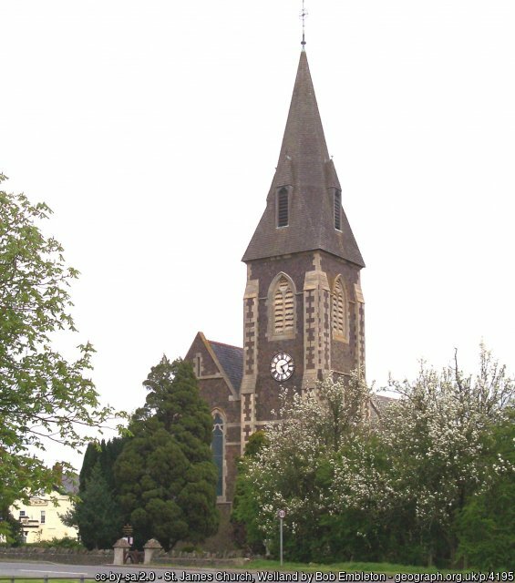
And yet, when looking more carefully, it becomes apparent that something is “wrong”. Where are the old houses? And why does the church look suspiciously new, very similar architecturally (and therefore presumably of similar date) to the school? Why are there still so many green spaces around the crossroads, despite the new housing developments? Indeed, why is there so much available space in the centre of the village for blocks of modern housing if the village is actually old?
Maybe the village is not old at all.
How to find out what is going on is the work of historical research, starting with the twin evidence sources of the landscape itself and historical documents. What do these two types of sources suggest?
Significantly, they hint that the village did not begin as a crossroads village at all but, rather, a more dispersed settlement of farms and houses, with several areas of focus – one around Welland Court and the “Old Vicarage” (a wonderful historical clue from the modern map), and another around Brookend. These areas are where concentrations of older buildings can be found, and both are some distance east of the current village focus.
A trip to the site of the old vicarage confirms that a church once stood close by. There is a grass platform raised up from the road, with access via an old gate and containing numerous gravestones, the newest dated 1875, the same year that the current church was built at the crossroads (according to the Victoria County History). Searching out the Tithe Map of 1847 and the Inclosure Maps of 1849 and 1851 (available at Worcester library) confirms these findings and also marks the position of the original schoolhouse, in the vicinity of Welland Court and the old church/vicarage.
Thus, Welland is not the crossroads village it first appears. Or, rather, it has not always been so. It seems that Welland began, and remained for much of its life to date, as a much more dispersed rural village. There is some evidence of ridge and furrow, indicating a degree of open-field communal farming, but perhaps other agricultural and contextual factors were also at work, leading to Welland’s particular form and functioning. The distinctive landscape features of Castlemorton Common, the Malvern Hills and the River Severn at nearby Upton surely had an influence on the village’s way of life.
There is plenty to investigate and document. This is the aim of the Welland History Group, and the purpose of this site. We hope you enjoy reading about the village and the results of our research.
