No major waterways pass through Welland but, like most settlements in Britain, water has strongly influenced its development.
Welland is situated on the A4104, an old road linking Upton upon Severn with the pass through the Malvern Hills at British Camp and on to Herefordshire. The settlement is likely to have developed as a direct consequence of this link to the Severn, an important waterway for trade and travel. Links are traceable as far back as Anglo-Saxon times and likely go back much further.
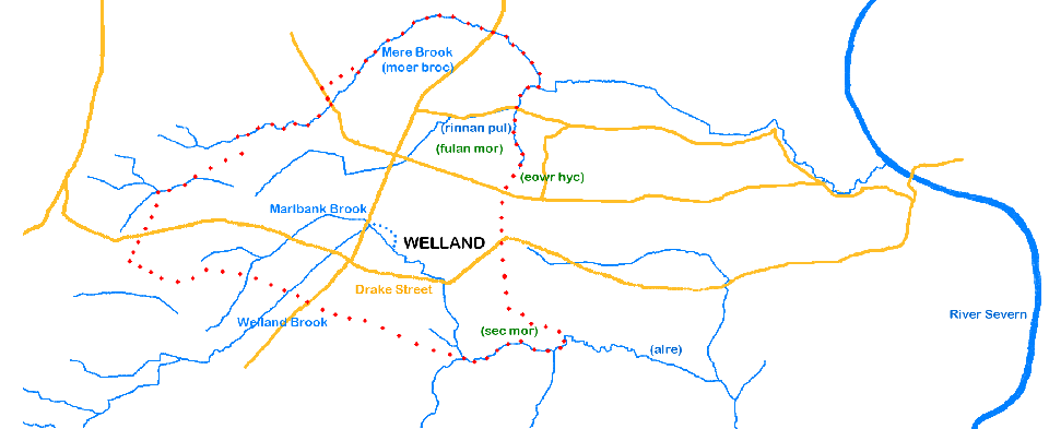
There are a number of smaller waterways within the parish and several are used to form parts of the boundary, no doubt because they are linear, relatively stable and easily identifiable features in the landscape.
In the clay areas of Worcestershire, streams are plentiful enough to enable settlements to be sited near a water source and also have others as boundary markers. Thus, Mere Brook forms a substantial part of the northern boundary of the parish (parish boundary shown in red dots), whilst Marlbank Brook and Welland Brook go through the settlement itself. Marlbank Brook and Welland Brook join at the B4208 as it heads north out of the village (see OS map). The Brook then flows down to and alongside Drake Street towards Upton, before heading south to join other streams and enter the Severn further south. The Brook forms part of the south eastern edge of the parish boundary.
The importance of waterways as boundaries is shown by the fact that we have knowledge of the Anglo-Saxon names of several of the waterways, small as they are, because they are referenced in charters of the time demarcating estates. These names can be seen on the map below (in brackets after the modern name on the map). The names in green show other boundary clause topological features – fulan mor (foul marsh), sec mor (sedge marsh) and eowr hyc (yew ridge) – the first two hint at how much drainage has taken place as the area was subsequently developed.
At first sight, Welland appears a relatively flat area but a look at a combined LIDAR/aerial image shows the lumps and bumps of the topography. It looks likely that Drake Street and the village itself are sited where they are because the Brook has cut through a ridge to provide easier access up to the higher ground and the Hills.
A water mill is known to have been sited soon after the confluence of the Welland and Marlbank Brooks. In the 17th and 18th century this was known as Archer’s Mill but it is likely that there has been a mill at or near this location before then. Structural remains and the ghost of an access track can still be seen at the site and the remains of the mill leat can also be found (see map, mill leat marked with blue dots).