Welland lies in what Natural England refers to as the Severn and Avon Vales Character Area. Landscape character is the distinct, recognisable and consistent pattern of the landscape which gives an area its “sense of place”. Landscapes evolve over time as a result of natural and cultural processes: natural processes create the physical structure of the landscape (geology, land form and soils), whilst cultural processes give rise to varying patterns of tree cover, field boundaries, settlement and routeways.
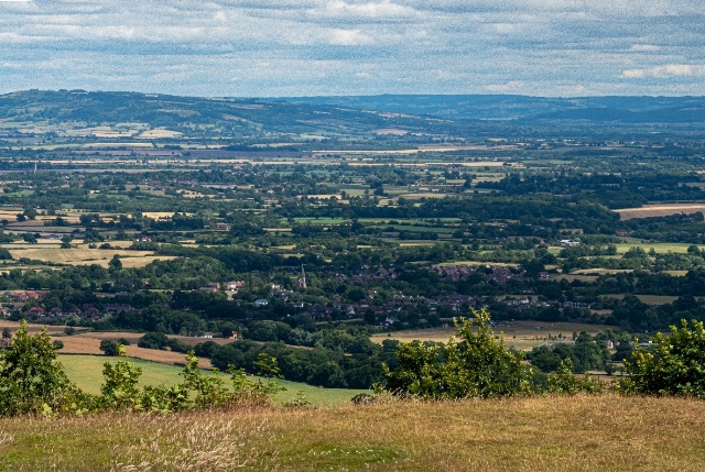
Welland lies on the land between the River Severn and the Malvern Hills, nestling at the point the land starts to rise. These two distinctive features have helped define the village, both its context and the way it has developed.
To the west of Welland, the Malvern Hills rise steeply from the Severn Vale and form an ancient boundary with the lands to the west, topped by Iron Age hillforts at Herefordshire Beacon and Midsummer Hill.
The River Severn divides two sharply contrasting landscape areas.
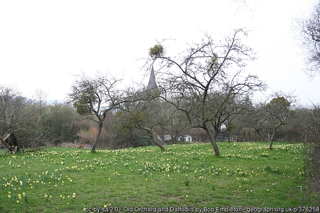
To the east, the land is underlain by Lias clays with occasional Cotswold oolitic limestone outliers such as Bredon Hill, and the soil is heavy but fertile. The area is characterised by nucleated settlements, arable farming and orchards.
To the west, the land is underlain by Mercia Mudstones, with banks of overlying superficial deposits (click on the map to see the deposit descriptions in the link) created by the processes of solifluction and gelifluction, and the soil is poor wet silty clay, not conducive to arable farming. Land use is predominantly pastoral. Settlements are more dispersed and a pattern of small to medium sized fields with an intermingling of fields and open commons has arisen as a result of piecemeal enclosure of the heathland from medieval times onwards.
In Welland, much of the west of the parish was part of Malvern Chase from the time of William the Conqueror, and land use was subject to strict forest law.
Common rights of grazing led to development of heathland but, prior to this, the area would have been heavily wooded. Although woodland is now sparse, there is still a relatively wooded feel to the area because of hedgerows and frequent hedgerow trees, together with remnants of orchards and trees in watercourse valleys.
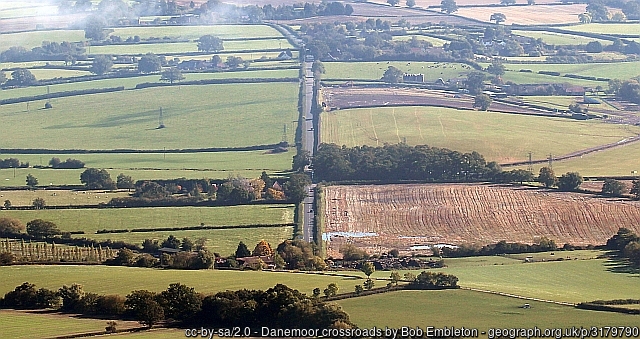
Larger regular shaped fields in Welland are the result of late enclosure of common land which took place in the 1850s. Some of these are now used for arable farming, such as rapeseed. The enclosed landscape is characterised by rectangular fields, straight roads and small blocks of planned woodland.
The contrasting landscapes on each side of the Severn may be one reason why Welland was part of the Bredon manorial estate in medieval times. Having parts of manor land on each side of the river meant that different landscapes could be exploited for different agricultural purposes – arable on the east bank, woodland resource management and grazing on the west, perhaps with some seasonal movement of animals from Bredon to Welland to take advantage of summer grazing.
Although Welland fits the general description of the area’s historic settlement and land use in some respects – such as examples of dispersed settlement over the parish, and assarted land to the west of Welland – there is also evidence of the common field system of crop rotation more associated with the area east of the Severn. Certainly, there were still remnants of three fields worked in common at the time of the Enclosure Act of 1851. There is evidence of ridge and furrow ploughing across much of the parish’s land that lay beyond the boundary of Malvern Chase and some evidence for as many as five grain mills in Welland and Little Malvern, a further indication that villagers were able to grow arable crops despite the paucity of the soil.
The area west of the Severn is characterised by settlements linked by a network of lanes, many leading from the river in the east to the higher ground of the west, some used for centuries as drove roads. This long-term use is especially clear where routeways have gone over higher ground and created deep cuttings over time (such as the A4104 as it passes through Marlbank north of the village.) Drake Street takes advantage of a natural gap in higher ground created by the Marlbank Brook and wayside dwellings, strung along the street at the heart of the village, nestle alongside.
Traditional building materials such as local stone and occasional Cotswold stone can be seen in older buildings throughout the area, though many are timber framed, sometimes with their original thatched roofs. Later houses are made of brick – older examples may have had their bricks made on-site using local clay.
Welland has several landscape areas that are protected or notable in one way or another. Part of the parish lies in the Malvern Hills Area of Outstanding Natural Beauty (AONBs are now known as National Landscapes) and there are several Sites of Special Scientific Interest (Mutlow’s Orchard, part of Brotheridge Green disused railway) or Sites of Regional or Local Wildlife Importance (Drake Street Meadow).