Welland’s lost medieval settlement
Not all settlements survive the test of time – they wax and wane over the centuries according to factors such as economics, climate and health. Welland is as susceptible to these factors as any other parish.
The 1628 survey map of Malvern Chase, made on behalf of Charles I in readiness for the sale of parts of his land, provides us with a snapshot of the area of the time. Most of Welland village is not shown as it lies outside the area of interest (the focus is very much on the Chase and its boundaries) but certain parts of the wider parish are indicated. On the eastern boundary of the Chase (marked in yellow on the map) an intriguing reference is made to a building and area marked Quab (its location on a modern Ordnance Survey map can be seen here).

The word “quabb” may derive from the Old English cwabba meaning marsh.
The South Worcestershire Archaeology Group (SWAG) undertook a survey in 1985 and were particularly interested by what they found in a field referred to as Quabb Meadow. Being left as a meadow (not built on or ploughed over in recent centuries) it had retained many historical physical features. The survey discovered evidence of a change in the course of the stream running through the area, several holloways, ridge and furrow plough marks, garden enclosures and hut platforms suggestive of a small deserted settlement, together with a larger platform surrounded by a ditch, perhaps indicating a small moated site. A curving holloway on the western edge aligns with the old boundary of Welland Common (though no evidence of the building marked on the boundary on the 1628 map was noted).
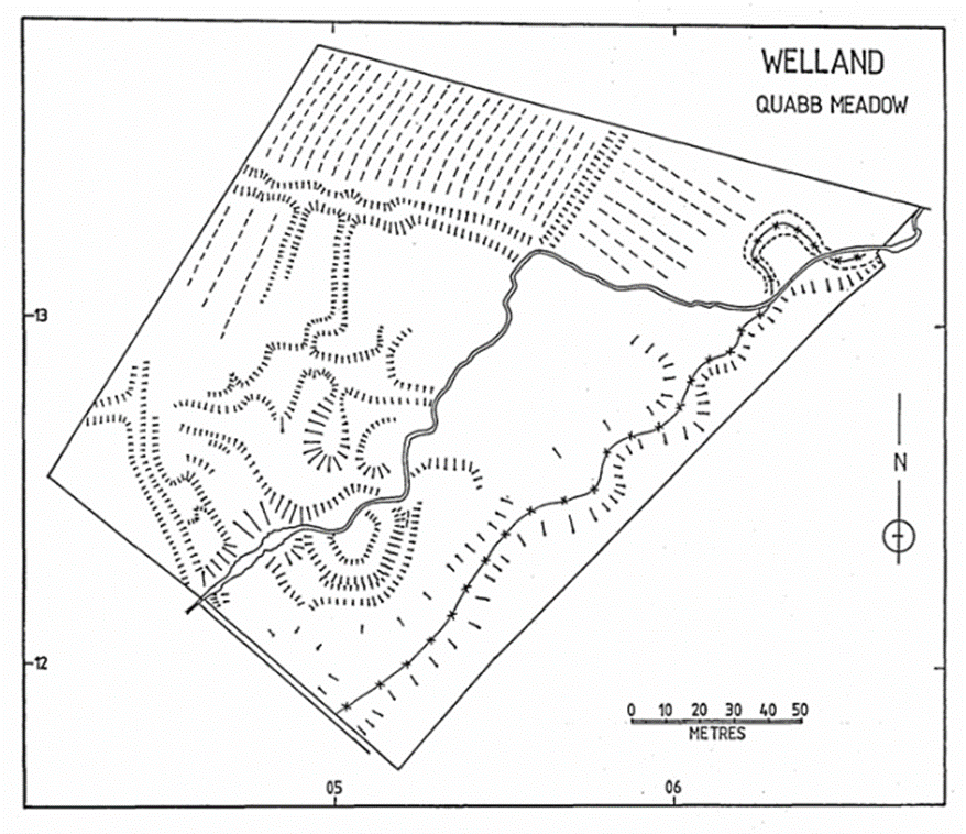
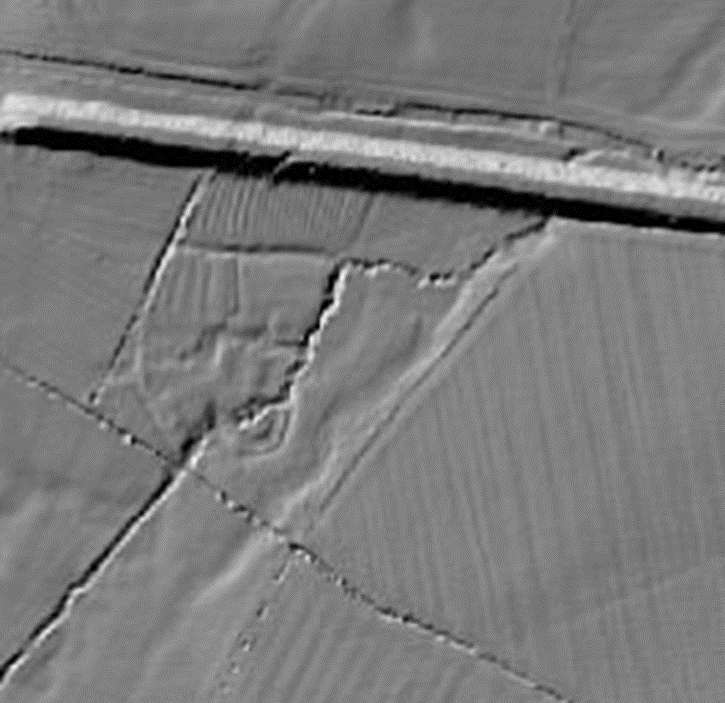
Modern LiDAR mapping (not available at the time of the 1985 survey) shows the landscape features discovered and documented by SWAG.
Thus, archaeological techniques back up the suggestion from the 1628 survey map that there was a small settlement at Quabb Meadow (perhaps served by Gilver’s Lane). But is there any historical evidence other than the survey map to back this up?
A perambulation of Malvern Chase boundaries in 1584 includes a reference to passing Hanley hall and Tyre Hill, continuing towards Welland by Gilvers Lane End and the Quabbs. As perambulations require fixed points of reference, this is likely to be referring to a specific settlement or building rather than an area of land.
A conveyance of 1658 concerning land belonging to the Earl of Dorset includes a reference to “the Quabbs, now divided into several closes” and a document dated 1667 relating to the Earl of Dorset’s lands refers to “…all that one close of pasture and meadow ground with the appurtenances called or known by the name of the Quabs containing in the whole by estimation 60 acres or thereabouts…”
Other documents of the 17th and 18th century reference land at the Quabbs, occasionally alongside references to buildings, but these are not clearly stated as being on the Quabbs. No buildings are marked on the 1816 Ordnance Survey map nor the 1847 Tithe Map of the area. We have not been able to find a reference to the demolishing of the property.
The historical documents indicate that The Quabbs (settlement and land) was about 60 acres and is likely to be the area shown here with field names (from the 1847 tithe map):
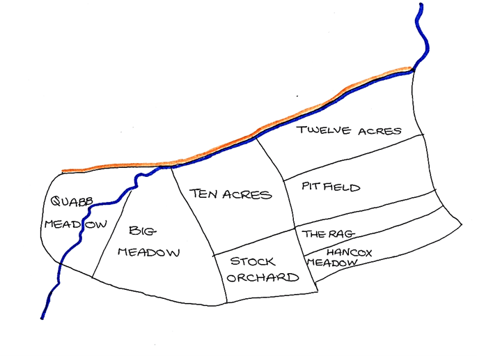
The shape, position and features of the land indicate that it was an assart (created at the behest of the landowner, the Bishop of Worcester) managed independently of the medieval village’s three common field crop rotation system. The shape of the eastern-most fields (long narrow inverted S shape) suggests that these were once ploughed ridge and furrow arable. The fields to the west, being wetter (proximity to the stream) were more likely to be pasture, a suggestion affirmed by the tithe map field names. However, SWAG did offer some evidence of ridge and furrow on Quabb Meadow itself (backed up by the LiDAR mapping), suggesting it was put to the plough at some stage in its history (medieval land pressure peaked in the early 14th century due to strain on agricultural resources as a result of population growth.)
The Quabbs holds a position of some importance in the history of the parish as it is the only area of medieval settlement we are aware of that does not have buildings still in place, thus leaving landscape evidence accessible to archaeological investigation.