Dank Moore and Daintmore are early spellings of the modern Danemoor.
The map of the 1628 survey of Malvern Chase shows an area called Dank Moore marked by two brooks. In the early 1630s a third of Malvern Chase was enclosed so that it could be leased or sold to raise money for Charles I. One of the enclosures in Welland was ‘St Giles Oake’ and this was where most of Danemoor farm’s land was located. Daintmore Farm certainly existed by 1724, when it is mentioned in the constable’s rate records, but it may possibly date back to the 1630s. Another of the enclosures, ‘Lumber tree playne’, was also part of the Danemoor landholdings but this was taken over by Charles Mayfield Turner in 1822, when James Price, the Bishop’s tenant of the Welland Thirds, went bankrupt.
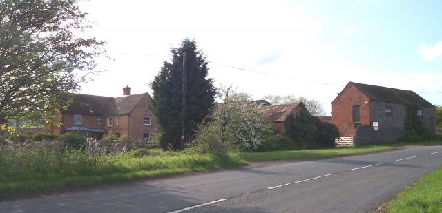
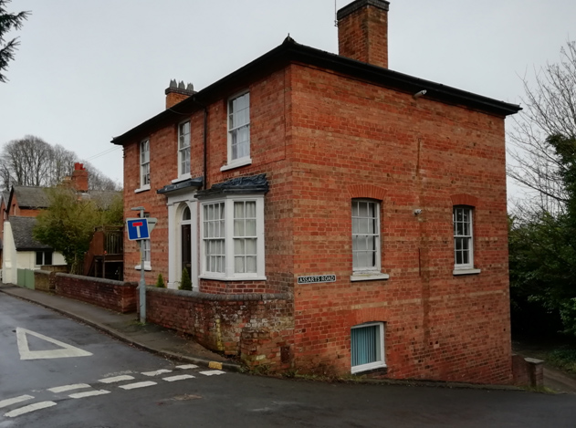
The farm buildings are arranged round a yard next to the house. The age of the current farmhouse is unknown but it is probably not the original one.
It is believed that the house registered by William Purser and five others as a meeting place for dissenters in 1788 was Danemoor farmhouse (see article about nonconformity in Welland).
On the 1812 Ordnance Survey drawing of Malvern Chase, Danemoor Farm can be seen on the edge of the enclosed land, with fields behind it and an orchard on the north side of the farm buildings, but the land between Danemoor and Welland was still part of Welland Common. This was divided up into fields under the enclosure award of 1853 and as part of this award, a road was built to connect Danemoor Farm with Welland. Blackmore Park Road leads from the crossroads straight towards Danemoor Farm then turns right up the hill towards Malvern.
Amongst the tenants was William Green, who was there by 1817, when James Price was the proprietor, and still there in 1833, by which time Thomas Jenkins owned the farm. Richard Hill had become tenant by 1839 and was still there in 1851, describing himself as a farmer of 96 acres.
The 1881 census shows that Alexander Roxburgh was the farmer at Danemoor and managing 196 acres. Born in Scotland in 1829, the son of a farmer, by 1861 he was a travelling draper in Dudley with a wife and children. Ten years later he was farming at Hockhams in Martley and at some point during the next decade he became the tenant of Danemoor. Alexander’s son David took over the tenancy from his father. The 1910 land valuation lists Duke Gandolfi of Blackmore Park as the owner of the house, buildings and 111 acres of land, and David Roxburgh as the occupier. It was the fourth largest Welland farm by acreage at this date.
By the time of the 1939 National Register, David Roxburgh was retired and Thomas and Mary Lloyd and their family were in residence at Danemoor.
John Barley’s parents worked at the remand home from 1947-49 and 1956-61. This article is based on John’s memories of his time in Welland, supplemented by open source material.
The 19th century vicarage on Marlbank Road (see map) housed Welland Boys Remand Home from 1944 to 1982. Remand homes were set up in the 1930s to accommodate children who had committed crimes and were being held in custody before being tried or sent to a reformatory. Welland’s was under the control of Worcestershire County Council, being one of approximately 60 remand homes in England. At any one time it could accommodate up to 25 boys, 8 to 17 years of age. The age of criminal responsibility was then 8, rather than 10 as it is today. The boys were generally there only for a short period of time.
Amongst the early staff at Welland Remand Home were Ralph Barley and his wife. Formerly a naval gunnery officer on mine sweepers during the war, Ralph was appointed Deputy Superintendent in 1947. His wife, a nurse, became Assistant Matron. They arrived with their young son, John, and took up residence within the building.
John’s parents left Welland in 1949 to work in children’s homes elsewhere but they returned in October 1956, when John was 12, taking up the positions of Superintendent and Matron. Their letter of appointment survives, detailing their salaries and the board and lodging fees that were deducted, but no mention is made in the letter of the existence of John or his younger sister!
The Barleys did not live in an apartment as such. Their rooms, a sitting room, bathroom and three bedrooms, were scattered round the building. The fact that John and his sister were living amongst a transient population of boys with a range of problems does not seem to have been an issue at the time. John, in fact, does not recall feeling threatened or fearful at any time. He did not mix with the boys much, except for table tennis, but recalls that they generally behaved well. The boys worked in the gardens, the woodwork shed and played sports. They had supervised walks on Sundays on Castlemorton Common. For some, this was their first experience of the countryside and animals.
John was in Welland for about 7 years in total. He remembers the cleaner, Mrs Olga Docker, who lived in Vicarage Cottage next to the house. There was a visiting gardener who grew vegetables on the land now occupied by the houses of Lime Grove. John used to mow the extensive lawns at the back, using an Atco motor mower, and trying to get the stripes right. He had keys to the front and rear doors, which were always kept locked. Boys did try to abscond on occasion but didn’t get far. One made it to Upton before he was caught.
John used to catch the bus each day to attend Worcester Royal Grammar School, as did several other Welland children. The 363 bus left at 7.45am and he caught the 4.45pm to return. He later bought an Austin 7 from a member of the remand home staff and taught himself to drive in the grounds. He re-built the engine in the workshop behind the house.
On Sundays he went off on his bike to attend Mass at St Wulstan’s at Little Malvern. He did gardening and farm work at Woodside Farm for Mr Broatch. His parents trusted him to go off on a cycling holiday to Essex with a schoolfriend and generally he was free to come and go as he pleased. John lived in several places as his parents moved jobs around the country but Welland is the one that stands out for him.
Reports in the Worcester Journal suggest that there were problems in later years at the remand home, with an increasing number of boys absconding. Minutes of parish council meetings of the time also highlight the issue. One example is from the early 1960s, when a supervisor, who was following a fleeing boy by car, called at a local’s home, Windyridge on Garrett’s Bank, to ask for help because he had run out of petrol. The owner provided a gallon for which he was paid four shillings and tenpence.
In 1970 it was decided to employ more supervisory, teaching and domestic staff to increase the ratio of staff to children, and to provide full-time education. Plans were made in 1972 to extend the building and build a staff house and garages. But the following year saw the end of the remand home system and a move towards more rehabilitative care. Welland House was later referred to as an ‘observation and assessment centre for 24 boys’ and a ‘special school’ taking boys that were deemed too disruptive to be in mainstream schools. It was recommended for closure in 1982 following a poor report. The property went up for sale in 1983 and became a care home, now Welland House Care Centre.
With thanks to John Barley, still a regular visitor to Welland, and also Neil Hancox, who supplied the anecdote about Windyridge.
Not all settlements survive the test of time – they wax and wane over the centuries according to factors such as economics, climate and health. Welland is as susceptible to these factors as any other parish.
The 1628 survey map of Malvern Chase, made on behalf of Charles I in readiness for the sale of parts of his land, provides us with a snapshot of the area of the time. Most of Welland village is not shown as it lies outside the area of interest (the focus is very much on the Chase and its boundaries) but certain parts of the wider parish are indicated. On the eastern boundary of the Chase (marked in yellow on the map) an intriguing reference is made to a building and area marked Quab (its location on a modern Ordnance Survey map can be seen here).
Malvern Chase 1628 Survey Map (west is at the top of the map, see full map at Europeana)
The word “quabb” may derive from the Old English cwabba meaning marsh.
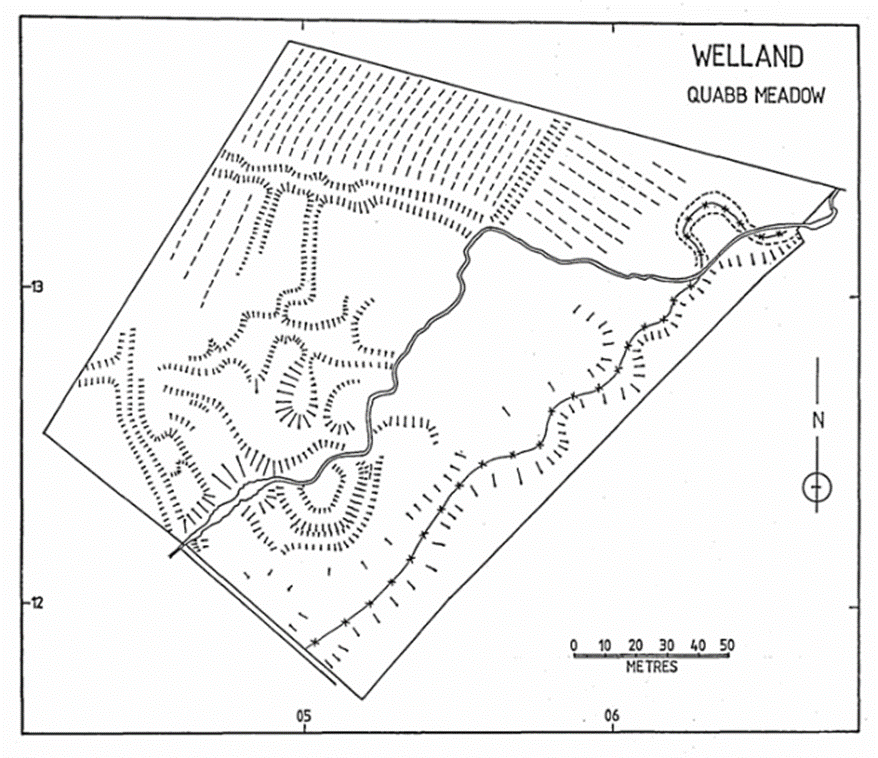
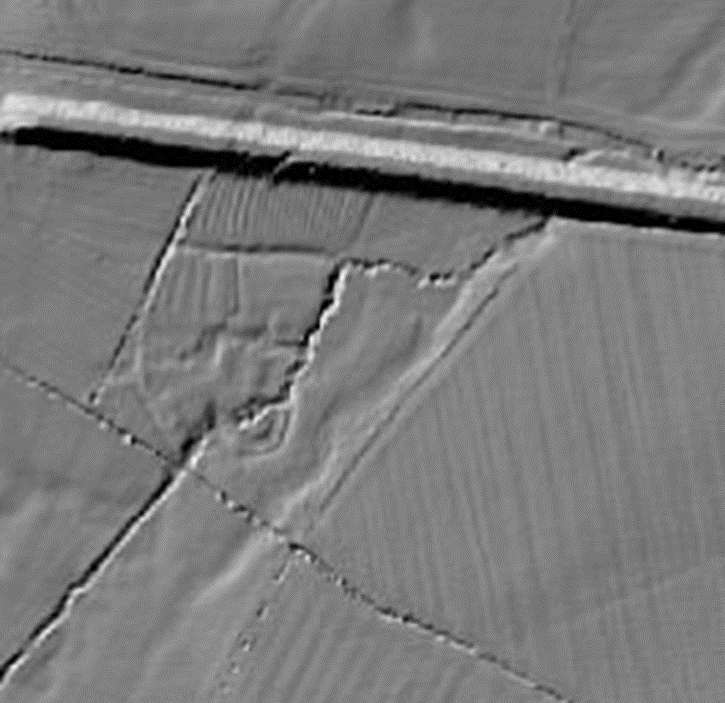
The South Worcestershire Archaeology Group (SWAG) undertook a survey in 1985 and were particularly interested by what they found in a field referred to as Quabb Meadow. Being left as a meadow (not built on or ploughed over in recent centuries) it had retained many historical physical features. The survey discovered evidence of a change in the course of the stream running through the area, several holloways, ridge and furrow plough marks, garden enclosures and hut platforms suggestive of a small deserted settlement, together with a larger platform surrounded by a ditch, perhaps indicating a small moated site. A curving holloway on the western edge aligns with the old boundary of Welland Common (though no evidence of the building marked on the boundary on the 1628 map was noted).
Mapping of landscape features found by SWAG 1985 (used with permission)
Modern LiDAR mapping (not available at the time of the 1985 survey) shows the landscape features discovered and documented by SWAG.
LiDAR showing location of survey. The heavy line to the north of the meadow is the embankment of a disused railway (cutting through the area of interest) and north of that is Gilvers Lane.
Thus, archaeological techniques back up the suggestion from the 1628 survey map that there was a small settlement at Quabb Meadow (perhaps served by Gilver’s Lane). But is there any historical evidence other than the survey map to back this up?
A perambulation of Malvern Chase boundaries in 1584 includes a reference to passing Hanley hall and Tyre Hill, continuing towards Welland by Gilvers Lane End and the Quabbs. As perambulations require fixed points of reference, this is likely to be referring to a specific settlement or building rather than an area of land.
A conveyance of 1658 concerning land belonging to the Earl of Dorset includes a reference to “the Quabbs, now divided into several closes” and a document dated 1667 relating to the Earl of Dorset’s lands refers to “…all that one close of pasture and meadow ground with the appurtenances called or known by the name of the Quabs containing in the whole by estimation 60 acres or thereabouts…”
Other documents of the 17th and 18th century reference land at the Quabbs, occasionally alongside references to buildings, but these are not clearly stated as being on the Quabbs. No buildings are marked on the 1816 Ordnance Survey map nor the 1847 Tithe Map of the area. We have not been able to find a reference to the demolishing of the property.
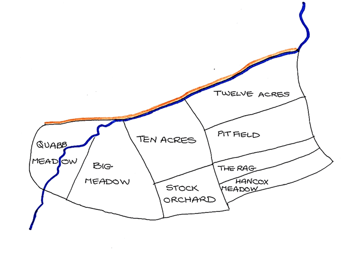
The historical documents indicate that The Quabbs (settlement and land) was about 60 acres and is likely to be the area shown here with field names (from the 1847 tithe map):
1847 tithe map fields. Also showing Gilver’s Lane and stream course
The shape, position and features of the land indicate that it was an assart (created at the behest of the landowner, the Bishop of Worcester) managed independently of the medieval village’s three common field crop rotation system. The shape of the eastern-most fields (long narrow inverted S shape) suggests that these were once ploughed ridge and furrow arable. The fields to the west, being wetter (proximity to the stream) were more likely to be pasture, a suggestion affirmed by the tithe map field names. However, SWAG did offer some evidence of ridge and furrow on Quabb Meadow itself (backed up by the LiDAR mapping), suggesting it was put to the plough at some stage in its history (medieval land pressure peaked in the early 14th century due to strain on agricultural resources as a result of population growth.)
The Quabbs holds a position of some importance in the history of the parish as it is the only area of medieval settlement we are aware of that does not have buildings still in place, thus leaving landscape evidence accessible to archaeological investigation.
For virtually a millennium leading up to the beginning of the 16th century, the church in Britain was part of the see of Rome, recognising the Pope as its primary authority. There were, however, an increasing number of those who protested that the official church, in accepting certain theology and practices, had lost the true essence of the Christian faith. The complex story of the Reformation in England resulted in the breaking away from Rome by the church in England and the formal acceptance of these Protestant ideals. This new church inherited all of the existing parish structure and buildings, becoming known as the Anglican or Established Church, the Church of England.
Despite persecution, some continued to practise their Catholic faith in secret or under great duress. The significant role of Catholics in the history of Little Malvern and Welland is not covered here and requires a separate research article.
Since the Reformation, there have been many Protestant groups who have found themselves at odds with the Established Church and have developed their own practices and forms of worship. Whilst mentioning a range of nonconformist denominations this article does not attempt to describe them in any detail.
Rod Ellis’ book “Dissenters All!” demonstrates the variety and prevalence of nonconformist chapels across the Malvern area. The only surviving religious building still used for nonconformist worship in Welland is the Methodist Chapel in Upper Welland. The story of the chapel also covers the history of Methodism in Welland.
This article explores other strands of nonconformist faith and worship in Welland. The evidence for these individuals and their meeting places is often fragmentary, but taken together shows that dissenters were a significant presence in the parish.
Early Dissenters
A series of Churchwarden presentments from the 17th century provide the first glimpse of individuals who refused to worship in the Anglican Church of St James. In 1663 James Surman and his wife, widow Fellis and Ann Pratt did not “com to the publike”. This might have meant absence rather than dissent. The only person formally identified as a dissenter among the papers is Thomas Luddington who appears in the presentment of 1676. It is not clear why he was not named in other years. All of these individuals were of independent means and could weather any strictures that might have been applied to them. Thomas Luddington was not a Catholic, but the form of his dissent is not known.
Early Meeting House Registrations
Following the Toleration Act of 1689 it became legally permissible for dissenters to meet in public, provided that their meeting houses were officially registered. The first such that has been found for Welland was in 1788 when six men registered the “…dwelling House now in the occupation of William Purser”. This was probably Danemoor Farm. In 1818 Thomas Williams, who lived in the house called Brookend, registered a “…building part of his dwelling house… intended forthwith to be used as a place of religious worship by an assembly or congregation of Protestants…”. The nature of these assemblies is not made explicit and it is not known how long these properties were used as places of worship.
From the late 1820s things become somewhat clearer. The growing tensions between the various churches and denominations are revealed by the 1851 Ecclesiastical Census. The Curate of St James, Rev. Other Philpott, noted only 70 adults and 38 children (less than a quarter of the population) attended service on the day of the census and complained, “It may be observed that the Church, standing at the extreme boundary of the Parish, a large proportion of the Welland parishioners attend other churches”. There does not seem to have been much love lost with Benjamin Onions, who submitted a return for the Independent chapel in the parish, complaining that in 1835 the numbers of children attending the Sunday School had dropped significantly “… by the influence of the Established Church”.
The Independent Chapel and the Countess of Huntingdon’s Connexion
In 1830, the house of Boaz Wadley was registered by Protestant dissenters Boaz Wadley, Benjamin Onions and Richard George. This is now known as Day’s Farm. There is a link between this meeting place and the Countess of Huntingdon’s Connexion. The Wadleys and the Georges had their children baptised in their chapel in Great Malvern. The Education Return of 1833 noted that the Huntingdonians provided for the Sunday School and Bentley’s Directory of 1840 advertised “…a chapel in Malvern Wood occupied by the Lady Huntingdon’s Society, which will seat 120 persons”.
In the Ecclesiastical Return of 1851 Benjamin Onions untangles some of the history, but raises more questions in the process. He notes that “…before 1834 two rooms were rented for Sunday School and Service”. This was probably at Day’s Farm. The Independent meeting place that he described in 1851 was built in 1834 and, although known as the ‘School Room’, was used exclusively for worship and could hold 50 (although the general attendance was 40). Although it had been supported by the Huntingdonians in the past he noted “Services conducted by various village preachers of different denominations”.
Identifying the location of the chapel/meeting house and school room has generated considerable research. Boaz Wadley moved from the farm in 1835 which presumably prompted the construction of a new meeting place. Benjamin Onions was a shoemaker and lived at Midsummer Cottage prior to his father’s death in 1838 and the 1847 Tithe Map shows a cluster of buildings owned by him. One is a building where Chapel Cottage now stands and was described (misleadingly) as “House and Wesleyan Chapel”. Chapel Cottage was originally a pair of cottages which had very small rooms. It is more likely that Vero Cottage (now demolished) was the purpose-built chapel. Former local residents remember that it had a very large room at the front with open stairs and a big double-door on the side closest to Chapel Cottage. The residents in the 20th century did not use this room as it was too big to heat. The School Room may have been where the garage of Chapel Cottage now stands as it is shown as a larger structure on late 19th century maps.
The 1861 census for Welland notes a “Small Independent Chapel” next to a shoemaker’s shop in this vicinity. Noake’s Guide to Worcestershire published in 1868 states in the section on Welland that ” …the Dissenters have a small chapel in the parish.” This is the last mention of the chapel in Welland. Benjamin Onions had died in 1863 and the meeting place faded soon after.
Chapel Cottage
The United Brethren and the Influence of the Latter Day Saints
It is possible that some of the village preachers invited by Benjamin Onions to lead services at the Independent chapel were from the United Brethren. The key mover and shaker of the United Brethren was Thomas Kington. He appears to have been expelled from the Primitive Methodists in about 1833 and soon after began preaching all around the Malvern Hills. He registered dozens of cottages as meeting houses including in Malvern, Upton and on Castlemorton Common. Although a very local denomination they attracted a lot of followers in the rural parishes immediately around the hills.
In 1840 a mission from the Latter Day Saints in the US arrived in Herefordshire led by Wilford Woodruff and, according to their records, the leaders of the United Brethren and most of their congregations converted to Mormonism. Many of these folk then emigrated to Utah during the 1840s.
Woodruff’s journal entry for 22 May 1840 describes walking over the Malvern Hills from Herefordshire and dining with Brother Samuel Jones. This is probably the Samuel Jones who was living at Lombard Tree farm. Samuel Jones was made an elder and was responsible for five of the local congregations of Latter Day Saints (although none in Welland).
Henry Jones (not closely related to Samuel) was apprenticed to Benjamin Onions in Welland as a shoemaker aged 16 in 1831 and stayed there until at least 1836 when he set up business in Malvern Link. His parents and other members of the family were converted to Mormonism and they emigrated in 1844. Their letters to Henry tried to convince him of the need to convert and pleaded with him to join them, but he never did.
Brethren and the Gospel Hall
The ‘Old Hall’ halfway up Assarts Road is a small, but intriguing building which was used for a number of purposes in the 20th century before becoming part of a dwelling. In the 19th century it was mainly for religious use and all of the following references appear to be related to this building.
From the mid 1870s services were being advertised at the “Brethren’s Meeting Room” in Malvern Wells and in the 1880s at the “Schoolroom”. The 1861 census notes a “Wesleyan Chapel” half way up Assarts Road (but this is probably mis-named) and in 1901 a “Gospel Mission Room”. It stood at the end of a row of dwellings known as Pomona or Chapel Cottages. The entry in Littlebury’s Directory of 1905 reads “Assarts Schoolroom – Service on Sundays at 11 a.m. and 6.30 p.m.; Bible Reading on Wednesdays at 7.30 p.m.” and the 1905 OS Map labels the building as “Mission Room”. Kelly’s Directorys of 1912 and 1916 refer to a “Gospel Hall” in Upper Welland, but by 1921 “a Gospel Hall now used as a Women’s Institute”. It is unlikely that it ever was used as a Wesleyan chapel.
In 1913 the General Valuation Survey noted that the Gospel Hall had just one room with a boarded floor and a small porch and was leased for 21 years from 1893 to a Mr Woodward by Miss Diana Grubb. James Woodward lived in the cottages just below the hall and was presumably a member of the Brethren. There are various types of Brethren denominations. Given the use of the term Gospel Hall they were probably ‘Open Brethren’. Each church is considered a separate congregation, but there may have been some connection with the Gospel Hall in North Malvern. The Brethren do not have ministers.
Gospel Hall
Non-Denominational Missions
It is likely that there were rallies and missions in the area in the 19th century. There are two which are documented in Welland: one temporary and one more permanent.
Lady Henry Somerset was a philanthropist and temperance campaigner. She inherited the Eastnor estate and moved there in 1883 and launched a series of missions in Ledbury and the local area. In August 1887 her Gospel tent was in Welland. The Worcester Journal reported one of the meetings which was crowded and impassioned as “her ladyship… pressed people to accept the water of life freely asking them if the death bed was the time to find Christ”.
George Nesbit moved to Welland in 1877. He had previously been a Town Missionary in Berwick. He rented Hill View on Kings Road which had previously been the Wells Hotel. Sunday Services were advertised at the “Mission Rooms (Hill View)” during the 1880s. The censuses in 1881 and 1891 note George as “Missionary Minister” and “Scripture Reader”. George’s obituary in 1904 read, “Although he belonged to the Established church, he worked independently of any denomination…”. The house was put up for sale in 1896, “’Hill View’, containing 1 large room, formerly used for religious and other meetings”.
Hill View
Conclusion
The extent to which faith and religion were an integral part of the life of our forebears is easy to underestimate. The zeal of believers, as well as their commitment to a particular denomination, might seem alien to us in the 21st century. Over the years Welland saw a rich variety of nonconformist meeting places in homes or purpose-built structures. Denominations such as the Quakers or Baptists, which are characterised by more permanent buildings and burial grounds, are not represented, but this is not unusual for a rural parish such as Welland.
For a long time, the house on this site was the last one in Drake Street before Welland Common, hence the old name of ‘Streetend’. This name goes back at least to the manor of Welland rental of 1559 that refers to ‘the house at the Stretend’.
Streetend was a copyhold property belonging to the manor. Copyhold tenants owed specific duties towards the lord of the manor, the Bishop of Worcester, and were entitled to a copy of the title deed as recorded in the manorial court roll. Changes of tenancy were granted at the manorial courts. For example, at the court held in April 1633 it was reported that ‘Elinora Careles who held from the lord according to the custom of the aforesaid manor a cottage with curtilage called Streetend with two acres of land lying in Welland had died since the last court whereupon a heriot of 3s 4d fell due to the lord’. A heriot was a fee payable to the lord of the manor on the death of a tenant. The report goes on to say that Thomas Smith (possibly a relative) wanted to take over the tenancy and it was duly granted to him.
Fire & rebuilding
From later manorial correspondence it appears that the house partly burned down. A letter of 1807 from a Mr Bound reads, Yesterday I held court at Welland … I went over to look at Joseph Wagstaff’s cottage & premises he has rebuilt one end but it is a very indifferent place …’. Joseph Wagstaff took over the tenancy in 1789. The name Streetend seems to disappear about this time so perhaps it had fallen out of use by then.
We do not know whether the house that was burned was the one referred to in 1559 or a replacement.
By 1847, the tithe records show that the house and garden were owned by John Ward and occupied by Henry Wagstaff. The tithe map shows a small rectangular house in a comparatively large plot.
There should be references to the house in the 19th century census returns but unfortunately most of the Drake Street properties are not identified by name, making it difficult to match census entries with particular houses. Using the combination of census and land tax records, however, it is possible to identify some of the later occupants for Streetend.
George Jenkins
OS 1886 map showing Poplar Cottage (left) and the Post Office (both within plot 335). Reproduced with the permission of the National Library of Scotland
The OS map published in 1886 shows the plot had another building on it, the post office, as well as the cottage. George Jenkins, grocer and postmaster, owned both buildings and some of his tenants at the cottage can be identified.
Ann Symonds/Simmonds
1881, 1883
William Bridges
1885-1888
Thomas King
1889-1891
Thomas & Elizabeth Bickley/Beckley
1901
OS 1904 map showing the divided plot Reproduced with the permission of the National Library of Scotland
The 1904 map indicates the plot had been divided between the two properties. This may have been the first time in its long history that the Streetend two-acre plot had been reduced.
Mary Jenkins
The Valuation Office survey of 1910 describes the cottage as
‘Cottage & land 37 perches Brick and Tile in Fair Repair Kitchen, Back Kitchen & Washhouse 2 Bedrooms Outside: Privy, Pigscot, Shed & Pump’
The owner was O B Cowley (probably Oswald Beach Cowley, an Upton solicitor) and the occupier M A Jenkins. This is Mary Ann Jenkins, widow of George Jenkins, and she was still there for the 1911 census.
William Stanley
Stevens Directory of 1928 names William Stanley as the occupier of Poplar Cottage and this is the earliest reference to the current house name found so far. In 1921 William Stanley was living in Drake Street but it is not clear whether he was at Poplar Cottage or still at Church Cottage, next door, where he was recorded in 1911. William was a labourer at Cutler’s Farm, his wife Sarah was charwoman for Rose Pudge at the Pheasant Hotel and the house had four rooms. The couple had two young sons, Frederick and Charles.
William and Sarah were still living in Poplar Cottage in September 1939, when the National Register was compiled. By this time, they were in their 70s, with William working as a gardener. Frederick, in his late 20s, was still living there. He delivered letters and telegrams and was also a ‘part-time poultry man’.
Poplar Cottage today
Looking at the house today, there is a sturdy chimney stack at one end and the roof ridge has a slightly wavy line, suggesting the presence of old timbers. A vertical line is just visible on the white paintwork between the downstairs windows and the porch. This might indicate the division between the remains of the original house (on the left) and the section built after the fire in the early 19th century.
The modern house is larger than it looks from the front, having been carefully extended at the rear and on the first floor.
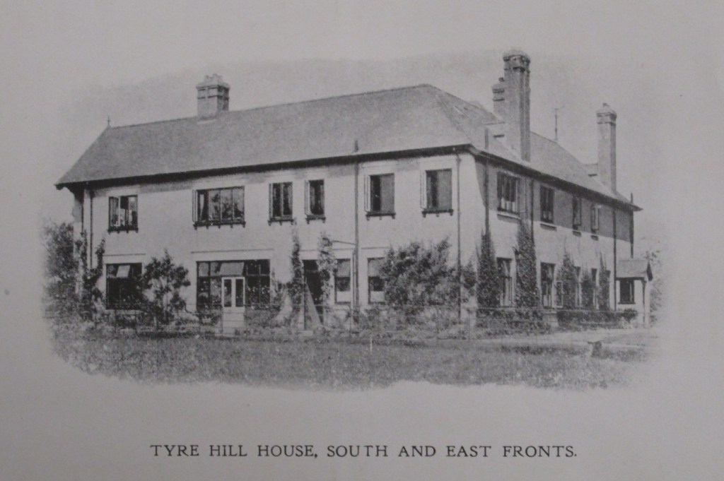
Tyre Hill House lies east of the B4208 (Welland Road) close to the boundary with Hanley Swan. The modern house is very different from the original house and associated farm buildings that survived until the late 19th century. These seem to have been close by, north-east of the current house.
The earliest known occupants of the Tyre Hill estate are the Badger family, whose names occur in the 16th and early 17th centuries. ‘Roger Bager’ appears in the Little Malvern Priory 1537 rental recorded at the time of the dissolution.
Giles Nanfan rented Tyre Hill in the mid-17th century. (The Nanfan family held the manor of Birtsmorton from 1424-5 until 1771.)
We get a glimpse of the house itself from owner William Chamflower’s will of 1709. The inventory mentions a kitchen, hall, great parlour, little parlour, ‘chamber next garden’, cheese chamber, buttery and malthouse, plus two chambers upstairs and a loft. The total value of the house contents and farming equipment, stock and crops, came to £782 7s 10d, showing Tyre Hill to be the property of a well-to-do gentleman.
Richard Randle, a later tenant to owner Mrs Baylis, gave up the estate in 1814 and an auction of farming stock was duly advertised: ‘Valuable Farming Stock, Implements in Husbandry, fine flavoured Cider and Perry, large Rick of Old Wheat, some Household Furniture, and other Effects’.
The Davis family of Hanley Hall owned Tyre Hill from the 1830s to 1901. The 1841 census shows the occupants of the house at ‘Tire Hill’ were John Drinkwater, agricultural labourer, and his wife, Nancy.
Possibly the same John Drinkwater was the occupier mentioned in Welland’s tithe records a few years later. He had the use of the house and garden while owner William Davis managed the agricultural land. The fields belonging to the estate were named as: the Forty Acres, Tire Hill Fold and Buildings Orchard, Cow Pasture, Red Hill, Tire Hill Orchard, part of a coppice, Flashers Ground, Broad Meadow, Gilliver Lane Ground, The Orles and the Old Hopyard. The tithe map shows the house and its fold of farm buildings a short distance north-east of the current house.
In the 1861 and 1871 censuses John Davis, carpenter and wheelwright, and his wife Mary Ann, were living there and there were probably labourers in occupation in 1881. There are no entries in the census for 1891 and 1901 so perhaps the house was no longer habitable or had been taken down by then.
A new chapter began in the estate’s history when Edward St Lawrence Walker, originally of Birstall Holt, Leicester, bought the Hanley Hall estate in 1901, and built a substantial house on the Tyre Hill site for his own use. He was a noted horse breeder and former Master of the Croome Hounds. Walker did not live to enjoy his new home for long as he died in March 1908.
Tyre Hill was then sold as part of the Hanley Hall estate in July the same year. The sales brochure describes a spacious seven-bedroomed house and includes mention of the house’s well, about 60 feet deep, from which water could be pumped and stored in cisterns in the roof of the house. The brochure also describes the entrance lodge on the Welland Road as newly built. The whole Hanley Hall estate was bought by Francis William Romney, a solicitor in Malvern. He seems to have rented out Tyre Hill but was living there himself in the late 1920s.
According to the 1921 electoral register, Tyre Hill Lodge was occupied by Lucie Jarrett, district nurse and midwife for Hanley Castle Nursing Association, and her boarder Sophie Hooke.
By the 1930s William Edward Charteris Watkinson, originally from Yorkshire, was living in the big house and running the farm. During WWII the house was sequestered for the war effort as a billet for troops. Watkinson joined the Home Guard and returned to live in the house after the war. He had an engineering degree and was keen on cars and steam trains as well as farming. He died in 1981.
Over the last few decades, the 1901 house has been extended and modernised. The surrounding land is now used by a livery yard.
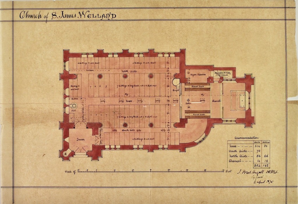
Floor plan for the new St James Church, architect John West Hugall (with thanks to Lambeth Palace Library for permission to use this image)
Several of the items on display in St James Church either have a connection to, or were brought from, the old Church of St. James. The current church (on the crossroads of the A4104 and B4208) is its replacement.
Seven specific items have been selected because they best demonstrate the continuity between the two churches even though their locations were a mile apart. There never was a village surrounding the old church or even a hamlet, but nonetheless the old Church of St. James was an important central pivot for the community and the point to which residents of the Parish gravitated. The old church and its replacement have been instrumental in shaping the way the history of the village evolved, so this website article has been designed to draw attention to this and also highlight the special connection between the two churches.
The location of each featured item is shown on the church floor plan:
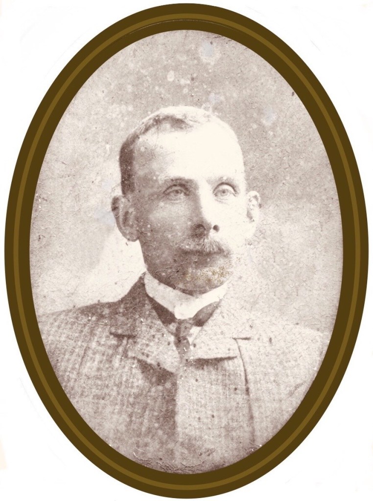
Curate of St. James’ Church, Welland, from 1864 to 1876, Vicar from 1876 until his death in 1882
Lionel Edward Darell Brown was born circa 1837 (estimated from census) and died on 11th February 1882 aged just 45. According to the Parish Register, he was conducting services until ten days before his death.
Lionel Brown and his wife Catherine were born in the East Indies. Lionel was born in Bombay where his father Henry was a civil servant. Catherine was born in Madras, her father was Physician General in the Madras Army. They married in Cheltenham – interestingly, the person who officiated at their marriage ceremony was Lionel’s uncle (his mother’s brother), the Reverend Sir William Lionel Darell. The couple soon relocated to Welland where their four children were born.
Lionel Brown was the Reverend Anthony Berwick Lechmere‘s nephew, so it was surely no coincidence that Brown came to Welland as Lechmere’s curate. The Revd. Lechmere was married to Lionel Brown’s aunt (his mother’s sister). Going back to Brown’s childhood in 1851, the Revd. Lechmere was living at No. 1 Churchend, Hanley Castle, with his wife and mother-in-law. The mother-in-law was Lionel’s maternal grandmother. Lionel was a live-in pupil aged 13 at the schoolhouse, No. 2 Churchend, so it appears that, as Lionel’s parents were still in India, he was sent back to England for schooling under the watchful eye of his aunt, uncle and grandmother. Lionel’s grandfather was born in Hanley Castle, so it is quite likely that a Lechmere / Darell connection had existed for some time.
From the time Lionel Brown came to Welland he lived at The Vicarage (now The Old Vicarage, next to Welland Court). In 1871 he was still there with his wife Catherine, three children and four servants. From 1874, he and his family lived at Heather Bank, Upper Welland, now known as The Chace Care Home. The New Vicarage in the village, Welland House, was built in 1880 at which time the Reverend and his family left Heather Bank and moved into it.
Lionel Brown came from a well connected family. His mother was Eliza Ann Verelst Darell before marriage, then she married Henry Brown. Eliza’s father was a 2nd Baronet and her brothers became 3rd and 4th Baronets. Around the time of Brown’s elevation from curate to vicar, he changed the family name to Darell-Brown by incorporating his third forename, which his wife and children subsequently adopted.
There was a very detailed account in the Worcestershire Chronicle dated 18th February 1882 of the Revd. Lionel Darell-Brown’s death and the subsequent inquest held at The Pheasant Inn, Welland. It was common in those days for inquests to be held at a local hostelry in the same village as the deceased. The jury concluded that although the cause of his death was clear – he had shot himself while alone in his bedroom – there was insufficient evidence to conclude whether or not it was deliberate, and an open verdict was returned. A friend stated that the deceased was known to be careless with the maintenance of his firearms and had been warned that it could result in an injury. Also, a member of the jury stated that he had examined the gun in question and found it had a very light trigger. The Reverend Darell-Brown left a wife and four children, the youngest of which was ten years old.
The story of his death is certainly a bizarre tale but it is worth noting that several details about his life came out at the inquest. The Reverend had been perfectly fit and healthy until the previous summer when he suffered an epileptic fit, from which he recovered. However, he had a second fit a week or so before his death. Prior to that he had been full of energy and had for many years past, as both curate and vicar of the parish, done everything he could to promote the welfare of the people committed into his charge. It was mainly through his exertions and with the help of friends that he, along with his predecessor the Revd. Lechmere, had been instrumental in getting a new church built in a more convenient place than the old one.
The aforementioned Reverend Sir William Lionel Darell, 4th Baronet (Lionel’s uncle), was the main landowner of Fretherne, Gloucestershire. When their old church needed a new replacement, he was the one who got it built and funded most of the work. Ten years later, in 1857, he paid for it to be improved and extended with a south aisle. The architect he selected for that project was John West Hugall. As Hugall was already known to the Darell family it would appear likely that the Darells recommended him to the Reverends Darell-Brown and Lechmere for the design of the new Church of St. James at Welland.
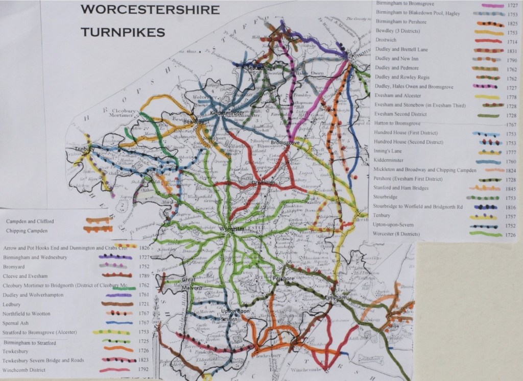
From the late 17th century, Parliament increasingly took responsibility for repairing and maintaining roads through Turnpike Trusts. Acts authorised a Trust to levy tolls on road users and to use the income to repair and improve the road. They could also purchase property to widen or divert existing roads. The trusts were not-for-profit organisations and toll levels had a maximum set, so it was supposed to benefit everyone. The “turnpike” was actually the gate which blocked the road until the toll was paid, so when a road was referred to as being “turnpiked” it just meant that it had toll gates across it.
The first Turnpike Act of Parliament was in 1663 and it turnpiked part of the Great North Road. By 1772 local area trusts covered more than 11½ thousand miles of road. By the time the last Act was passed in 1836, there had been nearly a thousand Acts for new turnpike trusts in England and Wales, at which time turnpikes covered around 22 thousand miles of road – about a fifth of the entire road network.
Locally, Welland was well served by turnpiked roads. The Upton-upon-Severn Trust included responsibility for Welland as part of the Worcester hub network, and the Ledbury Turnpike Trust (part of the Hereford hub network) linked into Worcester’s hub.
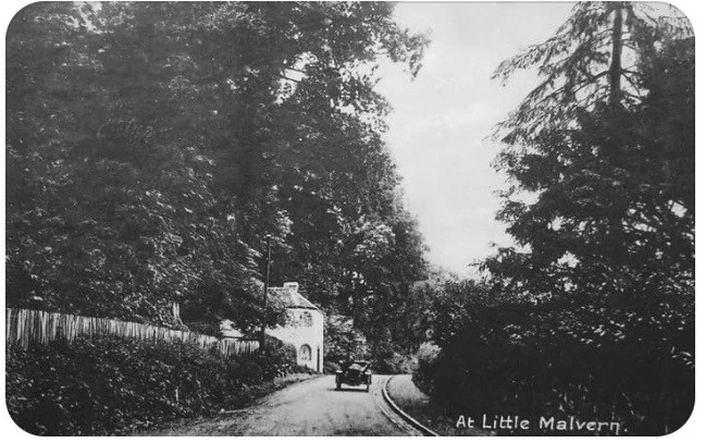
Welland had three tollhouses in close proximity, either in the parish or close to it. Little Malvern tollhouse on the A4104 was under the jurisdiction of the Upton Turnpike Trust, Twelve Mile Gate Cottage on the Malvern Wells road belonged to the Worcester Trust and the one just past The Malvern Hills Hotel beneath British Camp (see map) belonged to the Ledbury Turnpike Trust. Each tollhouse collected tolls for its own trust. Poet Elizabeth Barrett Browning made a reference to these three turnpikes in one of her diaries, writing that she had to pay at two tollgates when she went from home (near Wellington Heath) to visit her friend who lived at Malvern Wells, and if she also wanted to take the opportunity to drop down into Welland while in the vicinity, another toll charge would have to be paid.
Tollgates were often built at points were it was least likely that vehicles or horse users could evade payment, for example at bridges, crossroads or where the adjoining ground constricted the road. Hence many were built into a bank – as was the case with the three close to Welland. The tollhouses were generally placed outside urban areas. This avoided imposing tolls on local people and maximised the collection of charges on long-distance travellers. A downside was that these more isolated sites were vulnerable to thieves and highwaymen, so the windows of the tollhouse would routinely be fitted with stout bars and have built-in safes to protect the cash kept inside. However, many simple buildings were also built to house the pikemen who manned the gates on lesser highways. The classic design of a single story cottage with angled frontages dates from the 1820s when turnpike roads and the coach traffic they carried were at their peak.
Although the tollhouse itself was often the most prominent feature of the fare stage, as important to the toll collector was the gate. These were built to bar free passage along the road and were generally stout and substantial.
In 1840 there were still over five thousand tollhouses in England, but travellers had already started switching to the quicker railways, resulting in toll receipts dropping by a quarter over a period of just four years (from 1837 to 1841). In the 1870s, tollgates were opened to allow free passage – and just ten years later, the turnpike trusts ended and the tollhouses were gradually sold off.
Turnpike Trusts were responsible for the upkeep of roads and ensured they had a regular income by letting the tollgates to individuals. In some cases, tenants paid an annual rent to the trust and in return they were allowed to keep the tolls collected. Other times, the tollhouse was provided rent free but occupiers would hand over the tolls. It would appear from what we see on various census returns over the years that it was common for the wife to operate the toll gate and collect tolls during the day so the husband could work elsewhere.
The whole system of toll roads was very unpopular, as most people saw little improvement in the roads in the early days, found the frequent halts to pay the tolls very inconvenient and resented having to pay at all. In fact, it has been recorded that Mr Berington, a local Welland landowner, objected to paying the tolls – so the Trustees instructed the surveyor to pay him a visit and “acquaint him that the Trustees require him to pay the tolls at the gate the same as everyone else”.
Old postcard of Little Malvern tollhouse
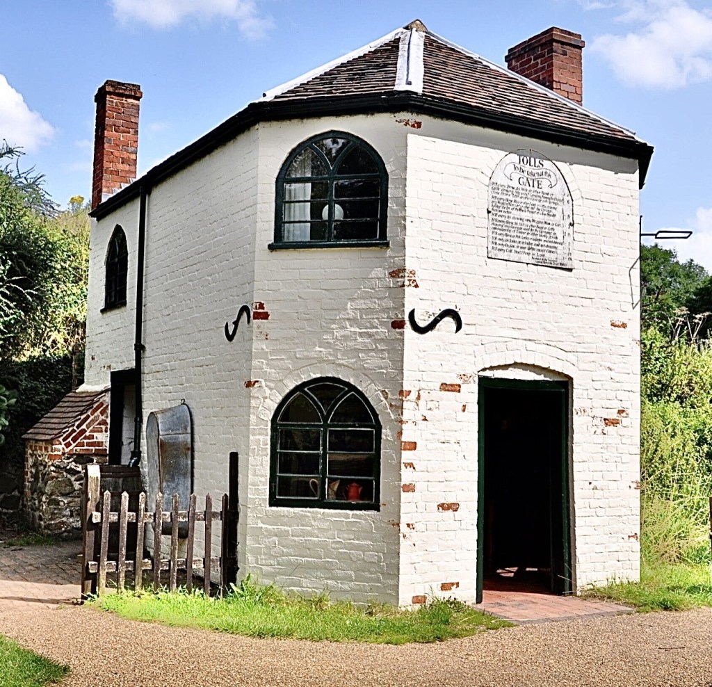
Little Malvern Tollhouse on the A4104 was built by the Upton-upon-Severn Turnpike Trust in 1822 at a cost of £56. It stood for over a hundred and fifty years at the top of the Welland to Upton Road just above Little Malvern Priory, after the sharp right hand bend but below the difficult junction with the A449 (see map). Windows faced both ways, so that there was a clear view in both directions of approaching traffic. This tollhouse was gifted to The Avoncroft Museum of Buildings in Bromsgrove in 1985 by the Berington Court Estate – it was subsequently removed and re-built, then restored and furnished. The tollhouse is a two storey brick building with a rear rubble wall of Malvern stone. The layout is somewhat quirky, being split level because it was built into a bank, so one enters the front at road level but exits the back door from the upper floor. During dismantling, a blocked up bread oven was discovered in the kitchen at the rear. The tollhouse had a timber built ‘earth closet’ (outside privy) that was also taken and erected next to the tollhouse at the museum.
Little Malvern tollhouse at Avoncroft Museum
The toll charge board currently on the front of the house is a not the original but a reconstruction, however, it is typical of the standard type of board that would have been displayed in the purpose built, arched niche in the front facade brickwork.
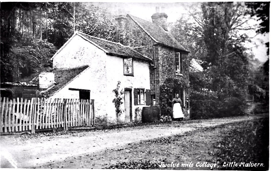
Twelve Mile Gate Cottage (see map for the location of the building, now demolished) was so called because it was exactly twelve miles from there to Worcester Cross, which is the crossroads right at the top of Broad Street, at its junction with High Street, St. Swithin’s Street and The Cross. Twelve Mile Gate Cottage had no electricity or running water, but it did have two gas mantles in the downstairs front room. The outside wall of the front room had a post box built into it. An outside privy was not uncommon then, but theirs was on the other side of the road, down some quite steep steps and several yards further on into the large garden area.
Milestones were erected by the Turnpike Trusts and can still be found along many roads. Only one in the parish of Welland still has its cast iron plate (see image below) although there is another just outside the parish, on the A4104 Welland Road by Lower Hook (see map). Both were erected by Upton’s Trust and have since been designated Listed Monuments by Historic England. Welland’s is on the Marlbank Road just west of the crossroads (see map). There are two other milestones along the A4104 in Welland but these no longer have plates (all three are marked MS on the map).
Danemoor Coppice is still marked on Ordnance Survey maps as a narrow strip of woodland between Danemoor Farm and Wood Farm (see map). A stream runs through it and there is a large pond at the eastern end. Patrick Campbell grew up in Welland in the 1930s and 40s and writes here about his memories of Danemoor Coppice, ‘Jones’s Wood’ as he knew it, when old fishery ponds still existed and the woodland was more extensive.
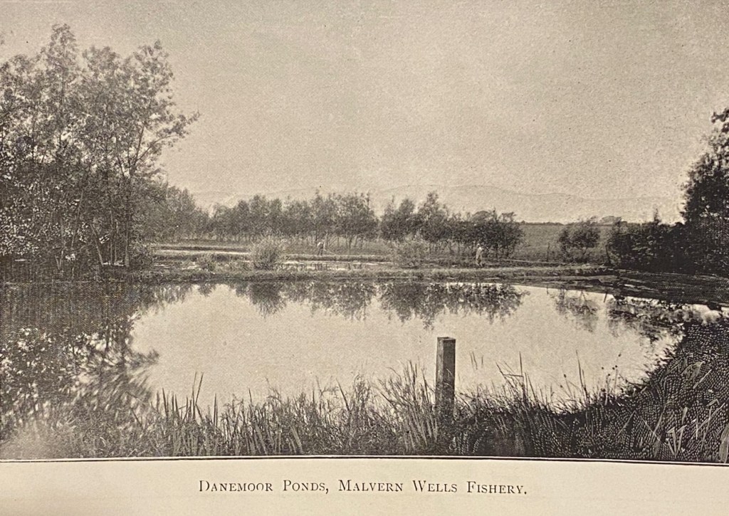
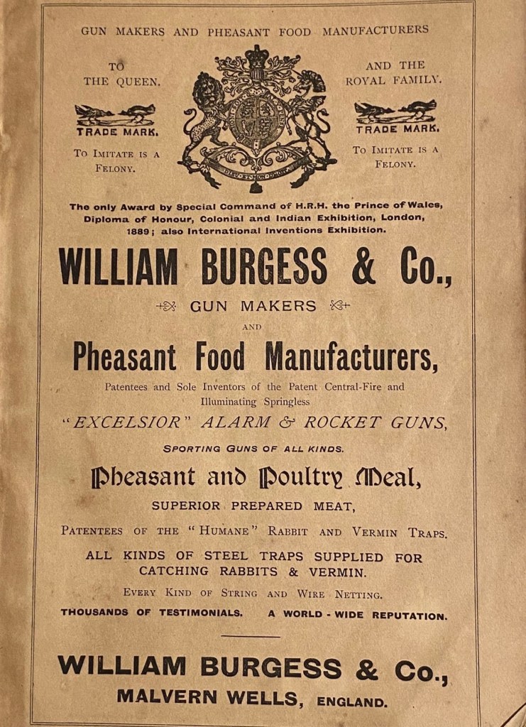
A series of fascinating images was recently posted online* by John Clements, whose family, close friends of my forebears, has farmed for generations at Brotheridge Green near Upton-on-Severn in South Worcestershire. The individual plates in an illustrated catalogue from William Burgess & Co, dated 1897, include photographs titled ‘View of Pheasantries at Malvern Wells’ and ‘Danemoor Ponds: Malvern Wells Fishery’, as well as earlier price lists of livestock, guns and line drawings of a wide variety of fiendish metal traps – including ones for poachers. All supplied by Wm. Burgess & Co, the proprietors of these twin establishments and self-proclaimed ‘Sportsmen’s Universal Providers’.
I say ‘fascinating’ because these pictures and price lists provide concrete evidence as to how the country landscape of this corner of England has changed over the past century and how, in a wider sense, we have become more humane and more considerate in our dealings with the natural world. Having said that, we have lost so many birds and beasts and so much of their habitat along the way, that there is nowadays no need for the hawk, kingfisher, heron, polecat and mole traps which Wm Burgess advertised with such enthusiasm. Of the eighty odd birds listed in his brochure as protected – and no raptor is included – a number are now threatened in the UK, including the quail, the bittern and the corncrake. Even familiars such as the barn owl and cuckoo are endangered.
I can offer no personal reminiscences about the pheasantry. Though it was sited on land adjacent to the fisheries – and the familiar outline of the Malvern Hills dominates the backdrop – it had, in my childhood, long since vanished: indeed, the sighting of a pheasant was always something of an event.
I had earlier encountered Danemoor Ponds on one of my many hikes around the countryside. It was, I recall, a hot July day, and I emerged from the tenebrous south end of Jones’s Wood to a most unexpected scene – five large, symmetrical expanses of water separated by narrow grassy dykes and fringed by alders, willows and reed mace. Beneath the surface of the last pool was something I had never seen before – long, subterranean shapes motionless in the warm upper layer of water. Ithrew a stick and they moved languidly. Pike. Big pike. Maybe ten or more pounds. The fiercest of British fishes. Confirmation soon came. There, high and dry in the willow herb, was a very dead pike that had maybe jumped out of its watery element to escape the jaws of hungrier brethren.
I later became close friends with Richard Lloyd whose father Tom owned Danemoor Farm, the site of these ponds. They marked the northern boundary of a two hundred acre estate, fed by a small rivulet that issued from a roach-stocked pool higher up on Henry Jones’s land at Wood Farm in Upper Welland. This brook snaked across open fields, entered the wood, and emerged again to flow into the first of the watery expanses.
That the five ponds were symmetrical was pretty obvious proof that they had been excavated manually, with a view to creating a commercial fishery. But the stratagem had not endured, at least not in the long term. What was a flourishing Victorian cottage industry that had won national awards as long ago as 1885, had now, sixty or so years on, reverted to nature’s embrace.
Nonetheless, the ponds still existed, now rented by the Severn River Board from the Lloyd family for the princely sum of £35 a year. The Board was probably responsible for dividing the original three into five and adding links between each stretch of water in the form of wooden sluices to control the flow. And as Richard points out in a helpful recent note, there were four valves to monitor the levels in each pond as well as a pipeline below the ponds which diverted water back to the stream.
It all sounds like an efficient arrangement. But the commercial heyday of the fisheries had obviously long since gone – the presence of rapacious pike was evidence of that. In a detailed description of the fishery in its prime, William Burgess’s brochure indicates that the original inhabitants had mainly been brown trout (salmo fario), not easy fish to breed. The ‘Fish Culture Establishment in Malvern Wells’ which appears to contain at least sixty tanks, was where it all started. Designed for ova and newly hatched fry, the young trout were then transferred from the hatchery to ‘a series of ponds’ (the Danemoor fisheries), up to ten feet deep, and designed specifically for ‘fry, another for yearlings and another for older fish’.
In an interesting aside, potential clients are informed that a railway station is conveniently close at hand, but counsels that ‘it is highly important that a suitable conveyance (on springs) should meet the train in which fish arrive, as delay at railway stations is often fatal owing to water not being kept in motion.’ Agitated water obviously meant oxygenated water. A precious cargo destined for the streams, lakes and tables of the hunting-shooting-fishing aristocracy of rural England.
The Burgess catalogue offered for sale – in addition to its staple of brown trout – perch and goldfish – presumably kept in separate conditions – ‘levenensis’ (sea snails with attractive shells from Madagascar), ‘fontinalis’ (willow moss, an aquatic plant for both cover and oxygen), and yearling ‘irideus’, rainbow trout not native to these isles, and presumably acquired from another source. The small print of patrons – perhaps one should say large print – is revealing: headed by Her Majesty the Queen and HRH the Prince of Wales, the impressive list of clients includes around 400 marquises, earls and other members of the English great and good.
Back to my childhood and the fish ponds. The word was out among my village pals that a mallard was nesting there, and since we were all avid egg-collectors, I decided on a sneaky search. It took all afternoon to find the nest, which was not, as I had expected, among the reeds, but in the crown of a pollarded willow. The pike had now gone, but I did note from a tell-tale ‘plop’ that a water vole had perhaps taken up residence. As for trout, no sign.
But there were brown trout in the vicinity. Less than a mile away was Marlbank Brook. It issues from springs in the granite outcrops of the Malvern Hills, cuts a deep swathe across Castlemorton Common and through Welland village, and eventually joins a larger confluence at Longdon. And it was home to trout. Not many and no great size, but beautiful stippled brown trout that I occasionally winkled out from the alder roots. I had often speculated as to how they had arrived there. And now perhaps I had an inkling. Though the brooks did not connect, someone who owned a stretch of stream had maybe popped a few in from the fishponds.
The confessional coda to this tale is both dispiriting and encouraging. Richard owned a 16 bore shotgun, and as teenagers we shot hares and wild duck from the cover of the grassy banks and sallies of the ponds. Next door, in Jones’s Wood we targeted woodpigeons, silhouetted against the night sky in the spectral winter trees. On the grassy pasture that was once home to pheasants, a covey of English partridges would whirr away in alarm, aware of our intentions. As far as I can recall, they survived.
Such activities and attitudes have long been in the past tense. When Richard left Danemoor Farm, having earlier inherited the estate from his father, the new owners decided to demolish the ancient broad-leaved woodland that was Jones’s Wood. No need for shotguns. Certainly no need for hawk or polecat traps.