Marlbank Farm

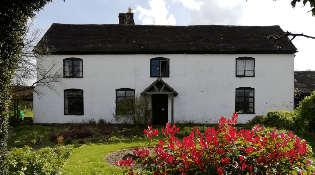
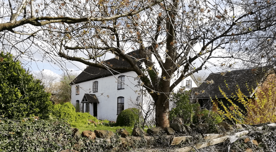
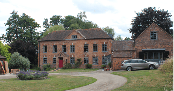
There is something a bit different about Marlbank Farm (see map). The main frontage looks much grander than you would expect from a typical local farm with two storeys and attics, but this grandeur belies the fact that most of the building is only one room deep.

Uncovering the history of the property has relied on a range of disciplines and contributions from local people.

The first description of the property comes from a series of deeds and mortgages commencing in 1778 and running through to the 1850s. The earliest refers to two properties: the homestead and a cottage called “Hills”, each with a small area of land (5 and 3 acres respectively). The deeds all relate to the Heming family, originally from Castlemorton, who owned the properties throughout most of this period and lived there from at least the end of the 18th century to the 1840s.

The 1828 tithe book refers to the whole property as “Lutwidges”, named after John Lutwich senior and his son, also named John, who owned and lived in the farmstead from before 1746. John Lutwich senior died in 1762 and his will refers to both properties: “Late Hills” being inherited from his father Richard Lutwich, and the farmstead from his mother Ann Lutwich nee James. Unfortunately at this point the documentary trail goes cold regarding the earlier history of the farmstead.

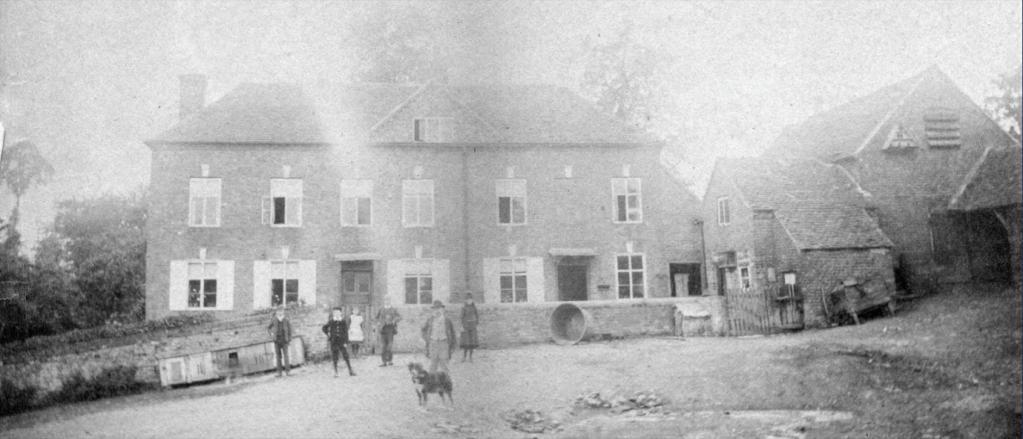
A specialist in historic farm buildings, Dr Edward Peters, visited the property in 1982 and his notes and observations provide an insight as to the age of the buildings. The keystone and window lintels provide key dating evidence for the construction of the building to about 1700. This ties in with the date mentioned in the Grade 2 listing for the house. He was also able to confirm that the house was all constructed at the same time, from bricks which were probably made on site (the current tenants have had some difficulty sourcing appropriate 2⅝ inch bricks for renovation work). He noted that one of the ground floor windows had originally been a doorway and this is confirmed by an old photograph of the Bridges family taken about 1890 (and is included here courtesy of Roger Wood).

Dr Peters made an enlightening suggestion that the property might have been built as a dower house. This does fit quite nicely with the fortunes of the Taylor family who lived at Welland Court. Edmund Taylor, the heir to Welland Court, was married in 1699 and his widowed mother Penelope lived until 1710. Welland Court itself was completely remodelled and encased in brick about 1700. Having somewhere for Penelope to live makes sense. Comparing the Constable’s rates of 1724 with the land tax of 1746 shows a reduction in the Taylor family holdings of a similar value to that for which John Lutwich was assessed in 1746.  Although this is only speculation it could explain a lot about the construction of such a grand looking house.

When Thomas Hemming senior died in 1811 there was an auction held on the premises of his household goods and movable items associated with the farm. This paints a picture of a general farm with mixed livestock and arable, but with a preponderance of cider-related equipment.  Newspaper adverts up until the 1870s extol the virtues of “Excellent Potting and Cider fruit growing in 7 Orchards” and in 1876 the sale of “4,000 gallons of very superior cider and perry, of excellent quality”.

The original 8 acres around the property grew to over 100 acres by the time of the Enclosure Award of 1852 and this remained fairly constant until 1975.

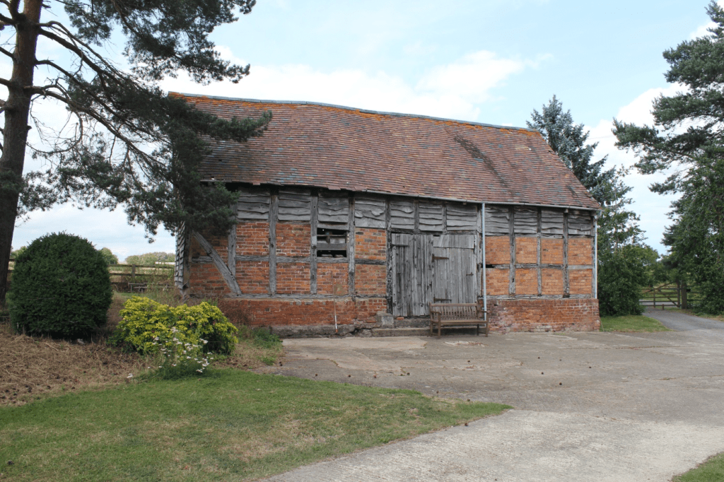
Some of the outbuildings still standing are quite early in date, particularly the Grade 2 listed threshing barn also built about 1700.  From the 1880s onwards there was a greater focus on livestock – maps and aerial photographs from the late 19th and first half of the 20th century show how these barns and shelters grew in number and size to accommodate more animals.

The farm was owned by several absentee landlords during the second half of the 19th century, before being bought by the Beringtons of Little Malvern Court in about 1907.  They owned it until 1947.  The tenants during the Second World War do not appear to have been very effective at farming and the property fell behind. By 1947 Edgar Fellows was the tenant and he had introduced several improvements including a generator for electric light throughout the house and buildings.

Marlbank Farm continued to be a large and productive farm until 1975, with the Ratcliffe family being the last tenants. The Berington family then re-purchased the estate, stripping off most of the land and selling on the buildings as a family home with scope for a variety of business opportunities. This has been the situation ever since.

Edmund and Marie Band

Edmund George Band was born on 26 June 1884. The son of a farm labourer, he was to become the headmaster of Welland school from 1930 to 1945. Edmund Band followed Mr. Pardoe, who had been the previous headmaster since 1922.

Edmund Band’s wife Marie, née Audebert, was born on 9 September 1880 and, up to the age of at least sixteen, lived in France. The first time we encounter her in England is not until the 1901 census.

In 1891 Edmund was living in Alfrick with his parents George and Elizabeth Band. By 1901, he was living in Chapel House, Alfrick, with his widowed mother – he was then a ‘pupil teacher’. At this time, Marie Audebert was living in Hopton Lodge, Hopton Lane, near Alfrick. The record states that she was ‘head of the household, living on her own account’ (which means that she was self-supporting). Her occupation was ‘dressmaker’, and her place of birth was Lignières, France. It is not unreasonable to surmise that Alfrick was where Edmund and Marie first met. They married on 3 November 1906 at St Edburga’s church, Leigh. One of their witnesses was Christina Featherstonhaugh, who had been Marie’s next-door neighbour when she lived at Hopton Lodge. (Christina lived at Hopton Court.)

By 1911, Edmund and Marie had moved to 12 McIntyre Road, St. John’s, Worcester, and Edmund was recorded as a teacher. At the time of the 1921 census Edmund was working at Hounds Lane Boys’ School and he and Marie were living at 105 Laugherne Road, Worcester.

When Edmund’s posting to Welland school commenced in 1930 they came here to live in a newly built, dormer bungalow style of property named L’Arnon. It was the first dwelling on the right after turning into Upper Welland Road from the A4104 Marlbank Road. This turning became known locally as ‘Band’s Corner’. The river Arnon runs right through Lignières, Marie’s birthplace, so it is not unreasonable to assume that is why their house was named L’Arnon. (The house has since been renamed Priory View.)

Patrick Campbell in his book ‘Plums to Persia’ recalls the house smelling of lavender and Edmund Band walking down Marlbank Road to school in the morning, pupils joining him along the way. He describes Band as ‘an early conservationist, and an unconventional teacher’.

After Edmund retired, the couple continued living in the same property. Edmund died in 1958 and Marie in 1960. They are both buried in Welland cemetery.

The photo shows Edmund Band with some of his pupils from Welland School in the early 1930s.

Rows 4 and 5 (back), order not certain:
Fred Woodyatt, George Rose, D James, V Bennett, 2 x unknown

Row 3:
Joyce Price, Sybil Woodyatt, Marjory Woodyatt, Lilian Godwin, Mr Band

Row 2:
Peggy Woodyatt, Joan Bennett, Oswald Wadley

Row 1 (front):
Gordon Bennett, Mavis Cooper, Frances Bennett, Roy Godwin, Raymond Woodyatt

Photo courtesy of Bernette Arrowsmith

Routeways

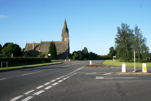
A dangerous crossroads until the 1970s when the A4104 road to Little Malvern was moved 100m to the north. The B4208 has priority over the A road. In the background is the parish church of St James.    © Copyright Bob Embleton and licensed for reuse under this Creative Commons Licence.

The earliest maps of the area do not show roads at all. Instead, they focus on watercourses as markers in the landscape. However, Speed’s 1610 map of Worcestershire shows a bridge at Upton, suggesting an east-west routeway through the region. Furthermore, Welland was part of Bredon manor in medieval times and goods and stock were transported between Welland and Bredon, again suggesting a regularly used route east-west. In the fourteenth century there are records of pigs from Bredon being sent to pasture in the woods at Welland and when logs were transported from Welland to the Severn by people from Bredon in 1395-6, a wassail was provided. Upton’s importance as a port created traffic through Welland – as early as 1289 the Bishop of Hereford had his wine sent from Bristol up the Severn to Upton, after which it was transported by land to his palace in Hereford.

It is possible that the east-west route has existed since prehistoric times. Welland lies close to the ancient frontier of the Malvern Hills, between a crossing of the River Severn (at Upton) and the Dobunni Iron Age hillfort at British Camp. Another Iron Age settlement (possibly a grain management site) has been found recently on the same route, on the far side of the river near Upton. The route extends on to Bredon Hill, yet another hillfort site. Thus the route passing through Welland may have been a significant part of the Dobunni communication and transport network.

At first sight, Welland appears to be in a relatively flat area but a look at a combined LIDAR/aerial image (zoom in towards the red dot and use the slider to view with aerial photography) shows the lumps and bumps of the topography. It therefore seems likely that the routeway, and possibly the village itself, are sited where they are because the brook has cut through a ridge here, providing easier access up to the higher ground and the Hills.

A 1628 survey map of Malvern Chase names the route as Drake Street as it passes through the village (still its name today). Drawings of houses on the 1628 survey map hint at the existence of other roads (or tracks) such as that along the edge of what was then Welland Common (now the B4208), and also Woodside Lane.

There will have been other routeways but these are not recorded on maps before the mid-nineteenth century. The road from Drake Street to Welland Court and the old church (see map) must have been a routeway for centuries. Byefield Lane (see map) is an example of a road that presumably existed in medieval times, passing as it does alongside Westfield, one of the village’s common fields. There are many footpaths over and around the common fields too – evidence that these have been rights of way for a very long time.

Some old routeways have been “lost” over the years. The 1628 survey map shows a route heading south in Little Malvern, at the base of the Malvern Hills and a 1720 plan of Little Malvern also marks this route, naming it as “the road to Gloucester”. This suggests it was a major road, now only discernible as various minor roads and tracks along the base of the steep slope of the hills.

Roadways did not always have a system of maintenance. From the sixteenth century, it was up to each parish to manage their road system and this was a haphazard affair, despite appointment of (unpaid) Surveyors of the Highways to supervise the work. Pot holes, ruts and mud abounded, resulting in frequently used routes becoming very wide as users tried to avoid the terrible conditions along the centre. A Welland example of local maintenance responsibilities comes from historical evidence from the sixteenth century that shows that the maintenance of the road bridge over the brook at Brookend was the responsibility of the one of the copyholders who was allowed to take wood from the Bishop’s land to maintain the bridge. But there are few references in Welland’s parish records to highway maintenance so it seems reasonable to assume that the parish did not make road maintenance a high priority. In 1633, Welland was one of several Worcestershire parishes to be rebuked for the state of its roads. During the latter part of the nineteenth century responsibility for the upkeep of the roads was gradually removed from the parish and placed in the hands of other authorities. However, one major road (what is now the A4104) ceased to be the responsibility of the parishioners much earlier than this. From 1663 onwards, turnpike trusts were empowered to build roads and levy tolls from users – see our separate article on Turnpikes and Tollhouses.

The A4104 remains a major route through Welland for traffic heading east-west between Upton on Severn and Ledbury, though the B4208 heading north-south has become a second significant road in more recent years, providing a route between Worcester and Gloucester (and to the M50). This road crosses what used to be Malvern Chase and, as the road crosses the southern parish boundary, it passes immediately into the largest remaining piece of the Chase, Castlemorton Common.

Other roads were created or enhanced as a result of the Welland Enclosure Act, as a result of which the part of Malvern Chase in Welland parish was enclosed. The Inclosure Map of 1849 marks the road from Danemoor Farm towards The Hook as “New Road”. Such roads are typically very straight, following new large field boundaries.

The crossroads of the A4104 and B4208 has stimulated recent development of the village around this point so that the area around the crossroads is now considered the village centre. The crossroads also demonstrates the continuing development of our road system – the school is now bypassed by the main road.

Early History

The origin of Welland is uncertain and little documentation exists for its early development. Medieval documents refer to it as Wenlond or Wellond, perhaps meaning that in Anglo-Saxon times the land belonged to someone called Wenna.

Prehistory

Although there is unlikely to have been any significant settlement here in prehistoric times, the village lies close to the ancient frontier of the Malvern Hills and is on the route from a crossing of the River Severn (at Upton) to the Iron Age hillfort at British Camp (now the A4104). Another Iron Age settlement has been found recently on the same route, on the other side of the river. It has been suggested that this settlement forms part of the system used by the local tribe, the Dobunni, to control the region, including the distribution of cereal harvests stored at sites in the Severn valley. The route extends on to Bredon Hill, yet another hillfort site. Thus the route passing through Welland may have been a significant part of the Dobunni Iron Age travel network. (See Worcestershire Archaeology report.)

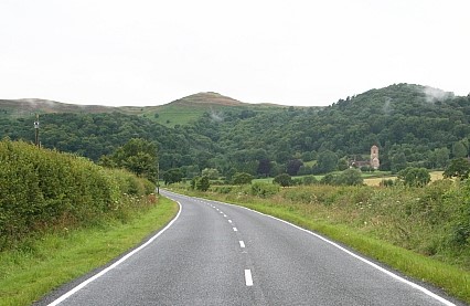
British Camp seen from the A4104 heading up from Welland

An archaeological evaluation by Worcestershire Archaeology (unpublished) was undertaken at Cornfield Meadows in 2020 (see map) and revealed a number of enclosure ditches and associated features at the northern end of the site close to the Marlbank Brook and its tributaries. It was dated by pottery to the later Iron Age and is probably an enclosed prehistoric settlement located within the fertile farmland adjacent to the brook. Evidence of extensive burning was recovered, including both heat affected pottery and Malvernian rock. The Malvern area provided a major regional focus for Iron Age pottery production, with rock from the hills used to temper locally produced pottery. It was therefore tentatively suggested that the site might have an association with pottery production.

Medieval

The first documented reference to Welland states that the village, together with Upton, was given to the Bishop of Worcester by Mercian lords in 889, perhaps as part of their support for the developing Christian church (the document’s authenticity is disputed.) The area was heavily wooded and it is unlikely that many people lived here – as late as the twelfth century the area around Malvern was referred to as wilderness.

Welland is not mentioned in the Domesday Book of 1086, probably because it formed part of the manor of Bredon. Several parishes in the area were subsidiary parts of manors further east in the more agriculturally developed zone of the Severn and Avon valleys. The western parts of the estates provided wood for tools, utensils, fuel and building, as well as woodland resources such as honey and game. Woodland areas were also valuable for the pasturing of swine – it may be that this began as a form of transhumance, the seasonal movement of stock from predominantly agricultural areas for summer pasture. Thus the linking of Welland with Bredon was on a sound economic principle, that of complementary resources.

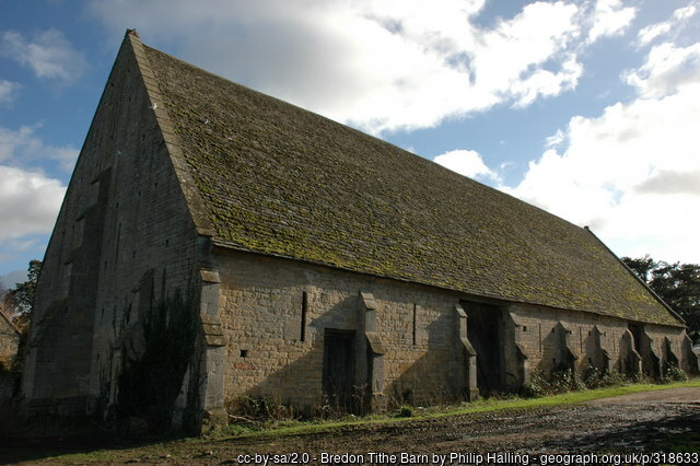
Bredon’s 14th century manorial barn

After the Norman Conquest of 1066, Welland was one of thirteen parishes that were incorporated into William the Conqueror’s Royal Forest, commonly known as Malvern Chase, and subject to forest law. The owner of the land (the Bishop of Worcester) and those living on the land were subject to rigorously enforced rules about the use of the land, which aimed to protect hunting rights. Some clearings had been made before the Conquest but after afforestation, no further clearings were allowed unless permitted by licence of the king.

34 acres in Upper Welland were freed from forest law by Richard I in 1189 and in 1196 the Bishop of Worcester was allowed to extend his clearing by a further 300 acres. Such clearance is called assarting and explains the existence of Assarts Road in Upper Welland. The assart was said to be “neare the Bishoppe’s myll of Wenlonde.” It seems that Upper Welland developed as a distinct community from early times, with another forming around the area near Welland Court.

Taxation assessments suggest that by 1280 approximately 80 people lived in the village, increasing to about 130 by 1327. The population was particularly dense in Upper Welland, perhaps because of the unusual economic approach of letting out assarted land to tenants for money rent. The standard land economy at this time was to let to tenants who paid their rent by manual labour on land (desmesne) retained by the lord of the manor (the Bishop in this case).

In the area around Welland Court, meanwhile, another community was developing along more traditional lines. There is little documentary evidence to support it, but it is likely that this community worked large open fields split into strips and apportioned to individual tenants, with the fields being managed on a crop rotation system. It may be that this community developed earlier than that at Upper Welland – though there is no documentary evidence to support this idea, the traditional agricultural approach and the presence of the Court and church suggest this may be so.

Peasants in the middle ages were mostly tenant farmers but there were also small-scale industries such as potting and tile-making (evidence of clay pits abounds).

The manor had probably been separated from Bredon before 1535 because, in the valuation of the bishop’s lands taken at that time, it is entered apart from Bredon and had a separate bailiff.

Railway

The Tewkesbury and Malvern Railway (a branch of the Midland Railway from 1st July 1877) ran from Ashchurch to Great Malvern via Tewkesbury, Ripple, Upton upon Severn and Malvern Wells (renamed to Malvern, Hanley Road from 2nd March 1951 in order to avoid confusion with Malvern Wells on the Hereford line). Construction started from the West Midlands Railway at Malvern and Tewkesbury junction on 1st July 1862. The line opened on 16th May 1864, connecting with the Worcester & Hereford Railway at Malvern and the Birmingham & Gloucester Railway at Ashchurch. The section of line from Malvern and Tewkesbury Junction to Upton passes through the northern part of Welland parish (see map). This section was closed to passengers on 1st December 1952 and the track between Malvern Wells and Upton was lifted in September 1953.

Traces of the line can still be found.

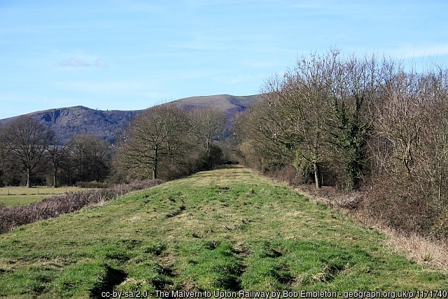
The embankment that lifted the line across a brick bridge over the road towards Hanley Swan (by the junction with Gilver’s Lane) are still clearly visible each side of the road, but the bridge itself was blown up in the early 1970s.

Gilver’s Lane and several footpaths provide views of the line but, for access to the line itself, try Worcestershire’s Wildlife Trust site which runs along the line and has access and a car park at Brotheridge Green, just outside Welland’s parish boundary (see map and the Trust’s website page for details).

A railway buff, Martin Theaker, has done a very informative blog about the line with many fascinating photos. You can find it here. The articles relating to the Welland section are Lumber Tree Farm, Gilver’s Lane, Hillcourt Farm and Brotheridge Green. The article about Gilver’s Lane has several wonderful photos of the Welland Road bridge being blown up!

Railway embankment heading towards the Malvern Hills. Taken from the western end of the Brotheridge Green nature reserve.

Lawn Farm

Much of the land once belonging to Lawn Farm, on Drake Street, is now part of the Pippin Drive housing estate built a few years ago (see map).

In 1806 Richard Harris is recorded as the proprietor of a landholding paying £2 16s 11d in land tax. The farm name is not given but other records allow us to identify the land in question as Lawn Farm. The current house, brick with some timber framing, was probably already in existence at this time and part of the building may have 17th century origins. The house is Grade II listed. (See Historic England entry.)

Richard Harris married Sarah Solloway in 1798 at Coddington. After Richard’s death in 1829, Sarah continued to farm the land, appearing in the land tax records as Mrs Harris. She married again in 1836 and appears thereafter as Sarah Hooman or Homan. Intriguingly, her husband John Hooman did not appear in her household in the 1841 or 1851 census and her later will states that they were separated. In the 1851 census she is identified as a farmer of 40 acres, 82 years old. Sarah died in 1855.

By 1858 William Harris, a nephew of Richard Harris, was tenant, but the farm was owned by Edward Pace, whose connection to Welland is unknown at present. The 1861 census records William Harris and his family, farming 50 acres. Still the farm is only identified as ‘Farm house, Drake Street’. William died in 1874 and the John Harris who succeeded him was probably his son. It was during John Harris’s tenancy that we see the name ‘The Lawn Farm’ for the first time, in a newspaper advertisment of 15 September 1879 (Worcester Herald).

The advertisement announces an ‘important sale of fruit’ produced by several growers, to be held at The Pheasant in Welland. Heading the list is ‘Mr John Harris, The Lawn Farm’ with crops from Cherry Orchard, Hill Orchard, Stock Orchard, Bacon Hill and Westfield for sale (presumably apples, but this is not stated). There was also a ‘row of damsons’ in Pig Orchard and the fruit of a ‘large walnut tree at back of the house, very thick’.

By the time of the 1911 census Francis Wastie was the owner. He was born in 1867 at Eynsham, Oxfordshire, where the Wasties were a long established family. The 1939 National Register records him at Lawn Farm as a dairy farmer, with his wife Edith, daughters Gladys and Edith, and son Frederick, all engaged in farm work. Another son, Frank Wastie, was working at Church Farm. After his father’s death in 1954 Frank took over Lawn Farm and the family owned it until at least 1979.

Welland Races

In the 19th century Welland Races were a popular one-day event, usually held in July, attracting spectators from Upton, Malvern and further afield. The number and quality of the horse races varied from year to year and they were supplemented by foot racing, ‘rustic sports’ and other amusements. Reports appeared in the Worcestershire Chronicle, the Worcester Journal and other newspapers from the 1820s to the 1890s but the event fell into abeyance for long periods at least twice during this time. The original race course was on Welland Common south of Danemore Farm (see map) but this was no longer available after the 1849 meeting as the land was enclosed. When the races began again in the 1870s Castlemorton Common was used briefly before the event moved to Danemore again as described below.

From 1846 spectators from Worcester could travel down the Severn on the paddle steamer Sabrina, disembarking at Hanley Quay. By the 1870s racegoers could also travel by train as far as Malvern Wells (the Hanley Road station).

James Archer, then owner of The Pheasant inn, was responsible for reviving the races in the 1840s and also acted as steward on at least two occasions. Mrs Mary Ann Ketteringham, The Pheasant’s landlady in the 1870s and 1880s, was frequently praised for her efforts as in this Worcester Journal report from 1873:

‘This annual event came off on Tuesday [22 July] at Dainmore [sic], the ground being kindly lent by Mr Watkins. The weather was fine, between 2,000 and 3,000 persons were on the ground, and there was capital sport. Refreshments were supplied in first-class style by Mrs Ketteringham, of the Pheasant, whose arrangements were as usual of the most satisfactory character. Four races had been announced but several others were added, and the meeting was a thoroughly enjoyable one. Hurdle and flat racing took place during the afternoon, and the several events were well contested. Formerly the horse races took place on Castlemorton Common, and the company had to return to a field near the Pheasant to witness the foot racing. This was an inconvenient arrangement, and the alteration made this year was a great improvement, and as such was highly appreciated by all who patronised the meeting. In the evening a ball took place at the Pheasant (the magistrates having granted an extension of closing time till two o’clock), about 100 were present, and the gathering was most successful …’

Evidently these were lively and well supported events, sustained in the village over a long period of time.

Smallpox Hospital

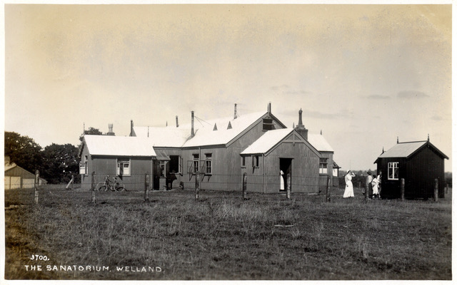
This postcard, dating from around 1915, shows the smallpox hospital that was once situated at the far end of California Lane (see map).

In the 1890s a small isolation hospital was built for Upton-on-Severn on the Upton to Welland road, intended for patients with infectious diseases such as measles, diphtheria and scarlet fever.

It was felt that an additional site for dealing specifically with smallpox cases would be useful and so this corrugated iron structure was built on a lane that went nowhere around 1905.

Smallpox vaccination was made compulsory in England and Wales in 1853 but it did not cease to be endemic until the 1930s. In the event, the Welland hospital seems never to have been needed for this purpose and it closed around 1944. A private house now occupies the site. To date we only know of one individual who was nursed at the Welland hospital: Ethel Hadley passed away there in 1919 from pulmonary tuberculosis.

Note the title of the postcard is ‘The Sanatorium’, perhaps slightly less ominous than ‘Smallpox Hospital’!

Corrugated iron buildings of this type were popular in the early 20th century for use as churches and community halls. Several examples survive locally, e.g. at Coombe Green, Hollybush and on the Upper Hook road.

We would be pleased to hear from anyone whose relatives are known to have been patients or staff at the smallpox hospital.

Photo: Peter Roberts – The Sanatorium, Welland

National School

The first school in Welland was built in Welland Court Lane under the auspices of the National Society. This organisation was founded in 1811 as the National Society for Promoting the Education of the Poor in the Principles of the Established Church in England and Wales. It promoted the building of schools to provide basic education to the children of the poor and was very closely linked to local parish churches and their clergy and congregations. Attendance was neither compulsory nor free although fees were subsidised by the church or parishioners for children whose parents could not pay.

In 1829 grants of £565 were made towards the costs of building the Welland school, which was put up on or very near to the green in Welland Court Lane, where the road forks towards Malthouse Farm (see map).

In the 1861 census records William Hillier was listed as a National School master and his wife Caroline a National School mistress. They were living in Drake Street so it is likely that they ran Welland school at that time. William was also the enumerator for the 1861 census in Welland.

Victorian schools have a grim reputation but a newspaper report from 29 June 1864 relates a happy event when 75 children from the school were treated to tea and games at Brookend House by invitation of Mrs Henry Green and her son, Mr Henry Green. The children ‘were marshalled by the mistress, Mrs. George, and led on to the spacious lawn in front of the house by the Rev. Lionel E Brown, the respected curate of the parish. Mrs Green and her son also invited many personal friends and parishioners to partake of her hospitality and to witness and join the games of the juveniles. After tea the children sang appropriate pieces, and with the visitors, entered heartily into various rustic games, including balls, croquet, foot racing, jumping and dancing on the green, to the strains of old John Heath’s violin, so well known in that neighbourhood.’ (Worcestershire Chronicle)

The National School was replaced in 1876 by Welland Board School, now Welland Primary School.

Primary School

Welland’s present day primary school on Marlbank Road was opened in 1876 as a board school with room for 120 children. It replaced the National School in Welland Court Lane and was designed by John West Hugall, also responsible for St James Church. The original school buildings included a house for the headteacher.

Board schools were a result of the 1870 Education Act, which allowed locally elected boards of officials to build and manage schools where they were needed, funded from the local rates.

Welland village hall, next door to the school, provided extra classroom space and dining facilities for the children during the mid-20th century.

Originally the school faced directly onto the road (now the A4104) but alterations to the crossroads in the 1970s diverted the road away from the village hall and school to give them some protection from traffic (see map).

Photo: Peter Roberts. Welland School c1910