Church Farm House

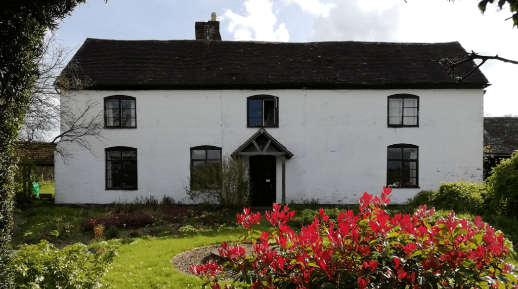
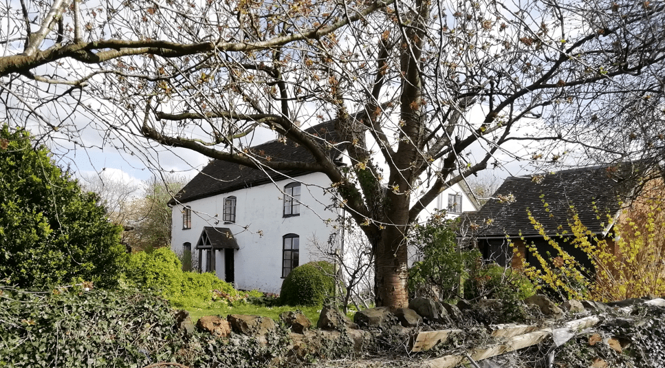
Church Farm House lies towards the western end of Drake Street (see map) and is relatively close to the current Church of St James from which it takes its name.  However the farmhouse predates this church and this site has been occupied for many centuries and the property known by at least six names. (Note: Church Farm House is not the same property as Churches Farm.)

The current building dates from the 19th century although an earlier building was mentioned in the will of Richard Lutwich. Written in 1745, he bequeathed to his daughter Mary “… freehold messuages lands and tenements and hereditaments lying in the parish of Welland aforesaid which I purchased of Richard Turbevile clerk and one Thomas Sandy”. The land tax prepared for the following year includes:
Richard Lutwhich… and for Turbavills £1 1s 8d.

Turbavills (various spellings) is the earliest name for the property and it must have been in their family for a considerable period of time, possibly back to the middle of the 16th century (although they may only have lived in Welland until the early 17th century).  John Lawrence was their tenant during the Civil War and he was assessed as having two hearths in the 1660s.

The rental for 1790 names the property as “Lutwiches or Turberfils” and occupied by Adam Hewitt. This leads to the third name, which appears in the 1828 Tithe book for Welland where the building is described as “Hewitts Homestead”.

John Morton of Worcester bought the farm in the first few years of the 19th century and he and his wife Ann owned it for nearly 75 years.  The farm included about 25 acres of land. The first of their tenants was Richard Harris, who was one of three occupiers over the next 150 years to combine with the larger Lawn Farm, creating a larger holding. Much of this land was given over to orchards.

The land tax records show that Joseph Goode was the tenant of the farm and the electoral register for 1846 onwards name the property as “Batchfords”, presumably a name that he chose.

The farm was still associated with about 30 acres of land in 1851, but when single brothers George and Henry Boulter (who had been farming at Hill Court) became tenants they increased the land holding. In the 1861 census they were 73 and 72 years old respectively and supported by two live-in servants. They were farming 48 acres and employing two men and a boy. 

The next tenants after this were Thomas and Emma Phelps who moved there in 1862, and eventually bought the property at the auction of the Morton estate (including two neighbouring cottages) in 1876.  By the time of the 1881 census the property was known as “Yew Tree Farm”.

Thomas Phelps was a significant presence in the parish.  He was elected parish constable in the early 1870s and was one of the Churchwardens during the period of construction and consecration of the new Church of St James from 1873 to 1875.  When an artillery camp was held on Castlemorton Common in July 1876, with soldiers attending from a variety of places, it was reported that the meat was supplied by “Mr Phelps, butcher of Welland”.  In the same month an auction of “two thousand gallons of prime cider, the property of Mr Thos. Phelps” was held.

By the time of the 1891 census, William (the 30 year old son of Thomas and Emma Phelps) and his wife Mary Ann were farming from the property.  This census is the earliest reference to the property as “Church Farm”.  This may have been the point where the smaller farm was reinstated as a separate entity and the name prompted by its proximity to the new Church.

The General Valuation Act resulted in a survey between 1911 and 1914 and described the building as brick and tiled with two sitting rooms, a kitchen and larder on the ground floor, four bedrooms and a landing on the first floor and two attics above. Outside, there was a brick and tiled butchers’ shop, as well as various thatched brick and half-timbered outbuildings, including a stable, barn and cart shed, and separate pig cots.

The Wastie family, who were known for their pioneering work with fruit, had moved to Lawn Farm soon after the Great War and combined Church Farm with their holding. Aerial photographs from the middle of the 20th century onwards show that virtually the whole estate was set to orchards.  Their son Frank was living at Church Farm at the time of the 1939 Register and into the 1950s.

The current owner uses the name ‘Church Farm House’. This may be because the property is no longer a working farm. The farmland has been sold, leaving only the house, barn, outbuildings and a small amount of land.

Marlbank Farm

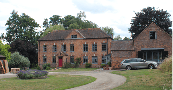
There is something a bit different about Marlbank Farm (see map). The main frontage looks much grander than you would expect from a typical local farm with two storeys and attics, but this grandeur belies the fact that most of the building is only one room deep.

Uncovering the history of the property has relied on a range of disciplines and contributions from local people.

The first description of the property comes from a series of deeds and mortgages commencing in 1778 and running through to the 1850s. The earliest refers to two properties: the homestead and a cottage called “Hills”, each with a small area of land (5 and 3 acres respectively). The deeds all relate to the Heming family, originally from Castlemorton, who owned the properties throughout most of this period and lived there from at least the end of the 18th century to the 1840s.

The 1828 tithe book refers to the whole property as “Lutwidges”, named after John Lutwich senior and his son, also named John, who owned and lived in the farmstead from before 1746. John Lutwich senior died in 1762 and his will refers to both properties: “Late Hills” being inherited from his father Richard Lutwich, and the farmstead from his mother Ann Lutwich nee James. Unfortunately at this point the documentary trail goes cold regarding the earlier history of the farmstead.

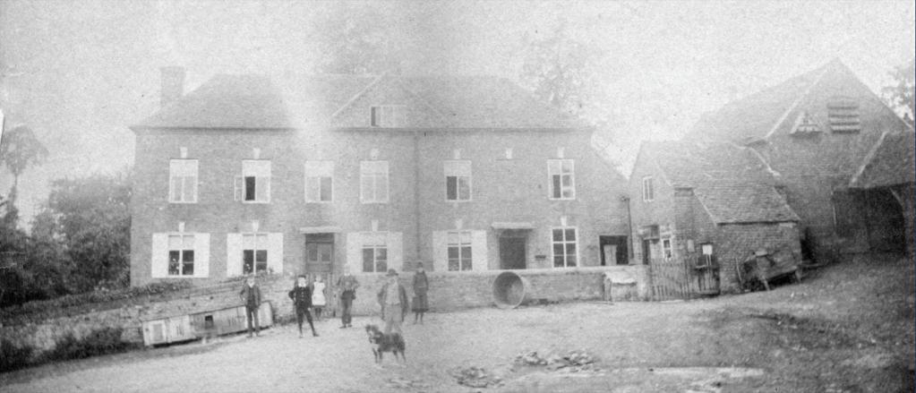
A specialist in historic farm buildings, Dr Edward Peters, visited the property in 1982 and his notes and observations provide an insight as to the age of the buildings. The keystone and window lintels provide key dating evidence for the construction of the building to about 1700. This ties in with the date mentioned in the Grade 2 listing for the house. He was also able to confirm that the house was all constructed at the same time, from bricks which were probably made on site (the current tenants have had some difficulty sourcing appropriate 2⅝ inch bricks for renovation work). He noted that one of the ground floor windows had originally been a doorway and this is confirmed by an old photograph of the Bridges family taken about 1890 (and is included here courtesy of Roger Wood).

Dr Peters made an enlightening suggestion that the property might have been built as a dower house. This does fit quite nicely with the fortunes of the Taylor family who lived at Welland Court. Edmund Taylor, the heir to Welland Court, was married in 1699 and his widowed mother Penelope lived until 1710. Welland Court itself was completely remodelled and encased in brick about 1700. Having somewhere for Penelope to live makes sense. Comparing the Constable’s rates of 1724 with the land tax of 1746 shows a reduction in the Taylor family holdings of a similar value to that for which John Lutwich was assessed in 1746.  Although this is only speculation it could explain a lot about the construction of such a grand looking house.

When Thomas Hemming senior died in 1811 there was an auction held on the premises of his household goods and movable items associated with the farm. This paints a picture of a general farm with mixed livestock and arable, but with a preponderance of cider-related equipment.  Newspaper adverts up until the 1870s extol the virtues of “Excellent Potting and Cider fruit growing in 7 Orchards” and in 1876 the sale of “4,000 gallons of very superior cider and perry, of excellent quality”.

The original 8 acres around the property grew to over 100 acres by the time of the Enclosure Award of 1852 and this remained fairly constant until 1975.

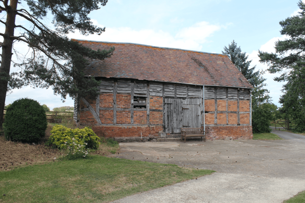
Some of the outbuildings still standing are quite early in date, particularly the Grade 2 listed threshing barn also built about 1700.  From the 1880s onwards there was a greater focus on livestock – maps and aerial photographs from the late 19th and first half of the 20th century show how these barns and shelters grew in number and size to accommodate more animals.

The farm was owned by several absentee landlords during the second half of the 19th century, before being bought by the Beringtons of Little Malvern Court in about 1907.  They owned it until 1947.  The tenants during the Second World War do not appear to have been very effective at farming and the property fell behind. By 1947 Edgar Fellows was the tenant and he had introduced several improvements including a generator for electric light throughout the house and buildings.

Marlbank Farm continued to be a large and productive farm until 1975, with the Ratcliffe family being the last tenants. The Berington family then re-purchased the estate, stripping off most of the land and selling on the buildings as a family home with scope for a variety of business opportunities. This has been the situation ever since.

Hook Farm

Hook Farm is some 400 years old, standing on land that once belonged to Little Malvern Priory (see map). Following the dissolution, all the priory’s lands in Welland were granted to William and Elizabeth Pinnock in 1545, William Pinnock being Lord of the manors of Hanley and Upton.

The farmhouse seems to have been built around 1600, as a deed of 1608 describes it as ‘newly built’. In that year Nicholas Cotterell, a tanner of Baughton, and his wife Alice, became the owners of the farm, then tenanted by Edward Doughty. The Cotterell family owned the farm until 1762, when the title was transferred to their tenant Joseph Curtis. It was inherited by his son, also Joseph, who died in 1828.

Charles Hastings (1794 – 1866) bought Hook Farm with 25 acres of land in 1833 for £1,550, following the death of Joseph Curtis’s wife. This was the famous Charles Hastings of Worcester Infirmary, surgeon, campaigner for improved housing and sanitation in Worcester, and one of the founders of the British Medical Association. His wife Hannah Woodyatt came from a Ledbury family, and Hastings spent the latter part of his life at Barnards Green.

During Hastings’ ownership the farm was rented by James Oliver. He appears with his family in the census returns for 1841 – 1871. The 1847 tithe map shows that common land still bordered Hook Farm to the west and south and the modern Hook Road did not yet exist. The farm at the time consisted of the house and farm buildings, a garden, and fields named Long Orchard, Broad Orchard Field, Lower field, The Two Acres, Bumpers Ground and Cow Pasture. The parish boundary between Welland and Upton ran along the eastern edge. A few years later, when Welland’s remaining common land was enclosed, Charles Hastings bought the land adjacent to the farm, adding about another 16 acres.

By 1881 James’ son George was in charge, working 40 acres and employing one man and one boy. George Oliver took over the lease in 1891 but also rented nearby Hill Court Farm, which is where he was living at the time of the 1891 census, Hook Farm being temporarily uninhabited.

After Charles Hastings’ death, his son George Woodyatt Hastings inherited a life interest in Hook Farm and Hill Court Farm. This was auctioned when he was declared bankrupt in 1896.

According to the census and other records, there were a number of occupants between 1901 and 1921. These included Thomas Clarke, a Mr Norrington, Walter Woodward and Oliver Ball. The farm was advertised for auction in 1918, following the death of George Woodyatt Hastings the previous year. It was then described as a dairy, stock raising and feeding farm with 51 acres of pasture, orchard and arable land.

John Henry Drinkwater was at Hook Farm with his wife and five sons by 1921 and is recorded on the electoral register at that address as late as 1949. After his death in 1950, the farm was bought by the Roberts family.

We are indebted to the late Mary Roberts, whose collection of deeds and other papers enabled us to establish the early owners and occupiers of Hook Farm.

Edmund and Marie Band

Edmund George Band was born on 26 June 1884. The son of a farm labourer, he was to become the headmaster of Welland school from 1930 to 1945. Edmund Band followed Mr. Pardoe, who had been the previous headmaster since 1922.

Edmund Band’s wife Marie, née Audebert, was born on 9 September 1880 and, up to the age of at least sixteen, lived in France. The first time we encounter her in England is not until the 1901 census.

In 1891 Edmund was living in Alfrick with his parents George and Elizabeth Band. By 1901, he was living in Chapel House, Alfrick, with his widowed mother – he was then a ‘pupil teacher’. At this time, Marie Audebert was living in Hopton Lodge, Hopton Lane, near Alfrick. The record states that she was ‘head of the household, living on her own account’ (which means that she was self-supporting). Her occupation was ‘dressmaker’, and her place of birth was Lignières, France. It is not unreasonable to surmise that Alfrick was where Edmund and Marie first met. They married on 3 November 1906 at St Edburga’s church, Leigh. One of their witnesses was Christina Featherstonhaugh, who had been Marie’s next-door neighbour when she lived at Hopton Lodge. (Christina lived at Hopton Court.)

By 1911, Edmund and Marie had moved to 12 McIntyre Road, St. John’s, Worcester, and Edmund was recorded as a teacher. At the time of the 1921 census Edmund was working at Hounds Lane Boys’ School and he and Marie were living at 105 Laugherne Road, Worcester.

When Edmund’s posting to Welland school commenced in 1930 they came here to live in a newly built, dormer bungalow style of property named L’Arnon. It was the first dwelling on the right after turning into Upper Welland Road from the A4104 Marlbank Road. This turning became known locally as ‘Band’s Corner’. The river Arnon runs right through Lignières, Marie’s birthplace, so it is not unreasonable to assume that is why their house was named L’Arnon. (The house has since been renamed Priory View.)

Patrick Campbell in his book ‘Plums to Persia’ recalls the house smelling of lavender and Edmund Band walking down Marlbank Road to school in the morning, pupils joining him along the way. He describes Band as ‘an early conservationist, and an unconventional teacher’.

After Edmund retired, the couple continued living in the same property. Edmund died in 1958 and Marie in 1960. They are both buried in Welland cemetery.

The photo shows Edmund Band with some of his pupils from Welland School in the early 1930s.

Rows 4 and 5 (back), order not certain:
Fred Woodyatt, George Rose, D James, V Bennett, 2 x unknown

Row 3:
Joyce Price, Sybil Woodyatt, Marjory Woodyatt, Lilian Godwin, Mr Band

Row 2:
Peggy Woodyatt, Joan Bennett, Oswald Wadley

Row 1 (front):
Gordon Bennett, Mavis Cooper, Frances Bennett, Roy Godwin, Raymond Woodyatt

Photo courtesy of Bernette Arrowsmith

Court rolls: 16th-17th century

Bredon and Welland

The manor of Welland was owned by the Bishops of Worcester for most of its history. It was first a sub-manor of Bredon, itself a possession of Worcester, so Welland matters would have been included in the court records for Bredon. The earliest court that took place in Welland for which we have a record is 1546, suggesting independence by that date at the latest.

From Marlbank looking towards Bredon Hill

What were the court rolls for?

Once Welland became a manor in its own right courts were held there twice a year to deal with changes of tenancy, infractions of the manorial laws and appointment of local officials. Original Latin documents survive at The Hive in Worcester for 44 of the years between 1546 and 1661. They were stored originally as rolled-up documents, hence the name.

These courts were held usually in the spring and autumn. Each document starts with a standard preamble naming the current bishop of Worcester, the sub-steward who conducted the court, the day it took place and the year. This is followed by the names of those who should have attended but had submitted an excuse, and the list of men of Welland who made up the jury. The jury presented the cases to the sub-steward and the details of these and any fines imposed formed the substance of the record. What we don’t know is where in the village the courts were held, there being no resident lord of the manor. Nor do we know whether people always paid the fines imposed on them! All the monies collected at the courts went to the bishop of Worcester, referred to as ‘the lord’ in the rolls.

What value do these documents have for us now? We can use them to assemble a picture of some aspects of life in Welland during the 16th – 17th centuries. Many individuals are named, almost all men, and at least some of the properties mentioned can be identified. The three large common fields were in use: Westfield, Merefield and Tiltridge. Tenants were expected to keep their ditches clear, allow pasturing of animals on their strips of land at certain times of the year, put up fences where necessary and keep their animals from straying. Bakers and brewers had to adhere to the set standards for weight and quality. When tenants took on a property, they paid a fee (a heriot) to the bishop of Worcester and swore fealty.  Sub-letting a property was generally forbidden and tenants could not take visitors into their homes overnight unless they had permission. On a few occasions the manor was fined collectively for the men failing to practise archery as required by law.

There would have been a few houses along Drake Street and we know from the map of the 1628 survey of Malvern Chase that houses extended along what is now Hanley Road and Woodside Lane by that date. The water mill along the Marlbank Brook was operational. The small village church and graveyard were next to what is now Welland Court. It is worth noting that the manor of Welland, owned by Worcester, did not cover the the whole parish of Welland as we know it today. Dauncies (called Welland Court from around the 1600s) and its estate, for example, were outside its jurisdiction, as was the land held by Little Malvern Priory. But the manor did include what is now Upper Welland.

Here are a few examples of typical entries.

Tenancies

John Badger, who held a messuage with appurtenances from the lord for 2s per year and owed suit of court, had died since the last court and 2s was due to the lord. An inquiry would be made as to who his heirs were. (October 1607)

A messuage was a plot of land with a dwelling house and outbuildings. Appurtenances were the rights attached to a piece of land. Tenants had to agree to attend the courts – this was called ‘owing suit of court’.

John Gwillam held a parcel of land called Hallhay and had died since the last court, whereupon a heriot fell due to the lord. His widow Elizabeth petitioned to be admitted as tenant herself according to the custom of the manor and made fealty to the lord. (April 1633)

Hallhay was probably near the junction of Woodside Lane with the Hanley Road. The tenant of Hallhay was also responsible for maintaining the pound and Brookend Bridge on Drake Street. The brook is now culverted under the road. Tenants had to ‘make fealty’, ie swear loyalty to the lord.

Drake Street near Little Brookend where the brook crosses under the road

Elinora Careles held a cottage with curtilage called Streetend with two acres of land and had died since the last court whereupon a heriot of 3s 4d fell due to the lord. Thomas Smith petitioned for admission to have and to hold the tenancy. He made fealty to the lord. (April 1633)

Curtilage was the land immediately surrounding a house. Streetend was once the last property on Drake Street before the common. The plot is now occupied by Poplar Cottage.

William Turner acknowledged he held certain free land for an annual rent of 3s 4d and suit of court that he had bought from John Salter, whence fell due to the lord 3s 4d. William made fealty to the lord for the first time. (October 1640)

Waterways

John Brawlard was fined 20s because he had diverted the mill stream from its right course. (April 1578) A year later it was noted that he had not yet returned the stream to its normal course. (April 1579).

John Brawlard was the miller.

Fences, ditches and lanes

Christopher More was fined 6d for not making his fence at Tiltridge (October 1586).

It was ordered that whoever had land in Westfield and Tippers Croft was to repair the lane leading to Westfield before the Feast of St John the Baptist or pay a penalty of 2s 6d. (October 1601)

Tippers Croft was just west of Brookend.Byefield Lane leads to Westfield.

Byefield Lane with Westfield on the right

Clement Saunders and Edward Smith were ordered to scour their ditches before the Feast of St John the Baptist. (October 1607)

Richard Baylis was to repair the fence between his property and Richard Long’s before the Feast of All Saints under penalty of 10s. (October 1637)

Sub-tenants and visitors

William Green was fined 3s 4d for sub-letting his property. (October 1589)

It was ordered that no one was to receive into his house any strangers to live unless authorised by the parish under penalty of 40s. (October 1637)

Foodstuffs

Hugo Vicarage and Richard Hunt, aletasters, broke the assize of bread and were fined 4d. (October 1594)

Thomas Falkoner and Thomas Shaw, butchers, sold meat without a licence from the lord and each was fined 4d. (October 1601)

Assaults

John Robins assaulted and drew blood from William Morgan and was fined 3s 4d. (October 1600)

Officials

John Badger was elected constable and Roger Pitt and William Morgan were elected tithingmen. (October 1594)

The tithingmen were responsible for enforcing law and order in the manor and reporting incidents to the court.

Woollen caps and archery

The men of Welland were fined 10s because they did not wear woollen caps on Sundays and feast days. (April 1593)

An act of 1571 had imposed this requirement on boys and men (except for those of rank) to boost the wool trade.

The men of Welland were fined 10s for not undertaking archery practice. (April 1633)

A succession of laws made from 1252 to 1541 aimed to ensure that England could produce enough skilled archers when needed. By 1633 the longbow had largely given way to firearms but evidently the law was still being enforced.

Home Guard

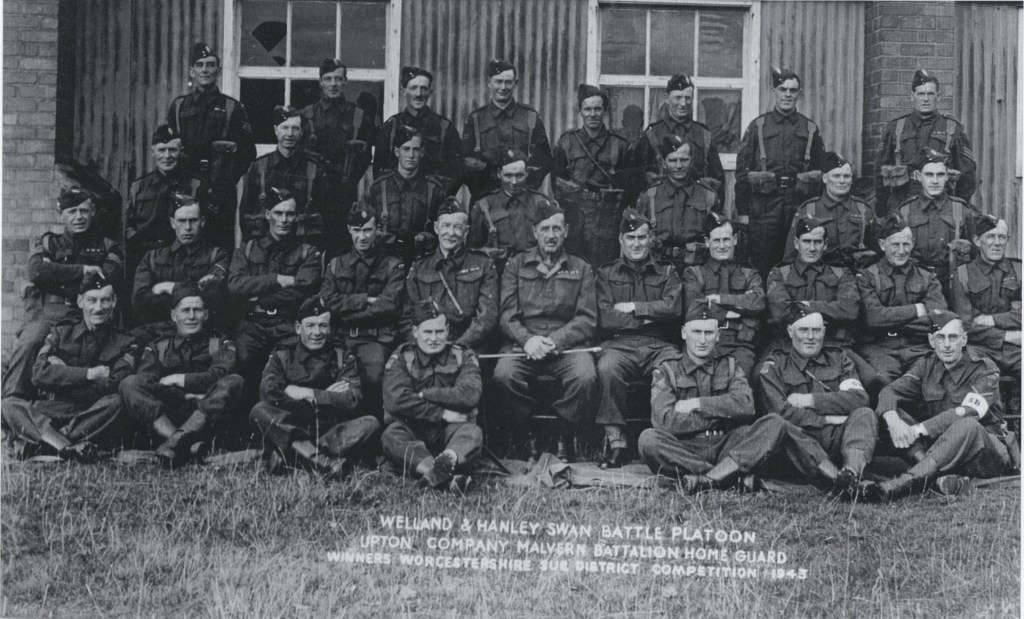
Welland and Hanley Swan Battle Platoon Home Guard, 1943

This photo and a list of names were supplied to us by Malvern Museum. The same photo, originally from the late Gordon Bennett of Welland, also appears in Mick Wilks’ Chronicles of the Worcestershire Home Guard (Logaston, 2014) with a slightly different list of names. The photo shows some of the men from Welland and Hanley Swan (HS) platoons, winners of the Worcestershire Sub District ‘Platoon in Attack’ competition in September 1943 (Wilks). We believe the building in the background may be Welland Village Hall.

From left to right:

Front row: Hubert Preston, Frank Hill, Ken Lawrence, Vernon Reece-Pinchin, Mike Hill, Harold Webb, Bill Shipman (HS).

Second row: Walter Reynolds (HS), George Pitman (HS), Owen Bayliss (HS), unknown, Lt (Col retired) C B Grice-Hutchinson, Major M F S Jewell, E C Watkinson (HS), Alec Dare, Ted Wheilden, G Dovey, Joe Dovey.

Third row: Harry Somers, Fred Carter, Raymond Hill, John Harbidge, Ernie Rouse, Charlie Wheeler, John Lewis.

Back row: John Allison, Don King, Bill Weaver, Joe Bullock, Dick Hart, Pat Oliver, Dennis Barnes, unknown.

Please get in touch if you can supply the missing names or think any of the identifications are wrong.

Little Brookend

Situated on the curve of Drake Street near to where the Marlbank Brook passes under the road, Little Brookend is certainly an old farmstead but we do not know just how old it is at present.

The land tax records indicate that William and Mary Bullock owned Little Brookend towards the end of the 18th century and it may then have been called Bennets. Their son Richard Bullock succeeded them.

William Twinberrow bought the estate about 1830. It was tenanted briefly by William Harris but William Twinberrow then farmed it himself. After William Twinberrow’s death in 1841 his great-nephew Joseph Twinberrow took ownership of the property, with Richard Tyler as tenant, and this was still the case when the 1847 tithe map was drawn up. The tithe records show that Little Brookend’s land at the time included four allotments in Tiltridge (one of Welland’s three common fields), nearby on the other side of Drake Street. Another plot of land, Smithfield (now Bidders Croft), lay further east along Drake Street. The farmhouse had an adjoining garden and orchard and the brook formed the western boundary.

At the time of the 1871 census John Bridges was at Little Brookend, farming 20 acres, and by 1881 the tenant was widow Ann Watkins, who described herself as a ‘market woman’ in the census.

The Tombs family had taken over by 1891. Mark Tombs was a carpenter and wheelwright as well as a farmer. He died in 1904 and his wife Rose in 1906. An auction arranged for 28 September that year advertised livestock, crops and numerous agricultural instruments and equipment.

The farm was bought by L D Stowe in 1906 and Elijah Smith took over the tenancy the same year. (L D Stowe may be Louisa Dorothea Stowe, known to be resident in Castlemorton in 1911.) A few years later, in February 1914, the Valuation Office survey described the farmhouse as brick and half-timbered, with a tiled roof and ‘in fair repair’. It had a hall, sitting room, kitchen, back kitchen, dairy, four bedrooms and a box room. There were also a cellar, loft, mill house, coal house, two pig cots, meal house, stable, coal shed, two outhouses and three sheds. The adjoining orchard and a plot of land in Tiltridge were still part of the farm. The market value was assessed at £800.

Elijah Smith was a poultry and dairy farmer, originally from Lancashire. At the time of the 1911 census his household consisted of his wife Blanche, three young daughters, Margery, Elizabeth and Leanore, and a farm labourer, Lugard Douglas Boswell. Blanche Smith remained in occupation until the mid-1950s.

Several of the farm buildings on the site have been converted into separate dwellings over recent decades, forming Mill Cottage, The Old Cider Mill and The Pottynge Barn.

Honeysuckle Cottage

This tiny timber-framed cottage in a small plot of land once stood set back from the road, next to Holly Cottage on Drake Street (see map). This photo was taken in the late 1940s and the cottage was demolished in the late 1950s or early 1960s.

Photo: Mick Woodward – Honeysuckle Cottage

We do not have a record of when it was built but it resembles cottages elsewhere that date from the 17th century.

The ground floor had a living room and a scullery. Stairs led up to the sleeping area under the eaves. A pump supplied water from a well and there was an outdoor privy.

The tithe apportionment records indicate that Thomas Hawker, an agricultural labourer, lived there in 1847, when the house was owned by Sarah Homan of Lawn Farm.

The land tax records indicate that Lina Reynolds owned the cottage from at least 1893 to the mid-1920s. With a rent of £4 per year it was one of the cheapest houses in Welland.  At the time of the 1891 census cordwainer William Lawley, his wife Mary, and their daughter were the occupants. From 1896 general labourer Joseph Jinnifer was the tenant, living there with his wife Clara and five children.

Records from the Valuation Office Survey show that the house was vacant when the surveyor visited in February 1914. The description reads ‘Cottage & Garden: brick, half timber & thatch in poor repair, with 1 Bedroom, Kitchen and Shed’.

At some point in the 19th century another house was built in front of Honeysuckle Cottage, hiding it from the road.

By the time of the 1939 National Register the house was occupied by William Hill, a coal haulier, and his wife, Rose, who lived their until their deaths in 1950.

Routeways

A dangerous crossroads until the 1970s when the A4104 road to Little Malvern was moved 100m to the north. The B4208 has priority over the A road. In the background is the parish church of St James.    © Copyright Bob Embleton and licensed for reuse under this Creative Commons Licence.

The earliest maps of the area do not show roads at all. Instead, they focus on watercourses as markers in the landscape. However, Speed’s 1610 map of Worcestershire shows a bridge at Upton, suggesting an east-west routeway through the region. Furthermore, Welland was part of Bredon manor in medieval times and goods and stock were transported between Welland and Bredon, again suggesting a regularly used route east-west. In the fourteenth century there are records of pigs from Bredon being sent to pasture in the woods at Welland and when logs were transported from Welland to the Severn by people from Bredon in 1395-6, a wassail was provided. Upton’s importance as a port created traffic through Welland – as early as 1289 the Bishop of Hereford had his wine sent from Bristol up the Severn to Upton, after which it was transported by land to his palace in Hereford.

It is possible that the east-west route has existed since prehistoric times. Welland lies close to the ancient frontier of the Malvern Hills, between a crossing of the River Severn (at Upton) and the Dobunni Iron Age hillfort at British Camp. Another Iron Age settlement (possibly a grain management site) has been found recently on the same route, on the far side of the river near Upton. The route extends on to Bredon Hill, yet another hillfort site. Thus the route passing through Welland may have been a significant part of the Dobunni communication and transport network.

At first sight, Welland appears to be in a relatively flat area but a look at a combined LIDAR/aerial image (zoom in towards the red dot and use the slider to view with aerial photography) shows the lumps and bumps of the topography. It therefore seems likely that the routeway, and possibly the village itself, are sited where they are because the brook has cut through a ridge here, providing easier access up to the higher ground and the Hills.

A 1628 survey map of Malvern Chase names the route as Drake Street as it passes through the village (still its name today). Drawings of houses on the 1628 survey map hint at the existence of other roads (or tracks) such as that along the edge of what was then Welland Common (now the B4208), and also Woodside Lane.

There will have been other routeways but these are not recorded on maps before the mid-nineteenth century. The road from Drake Street to Welland Court and the old church (see map) must have been a routeway for centuries. Byefield Lane (see map) is an example of a road that presumably existed in medieval times, passing as it does alongside Westfield, one of the village’s common fields. There are many footpaths over and around the common fields too – evidence that these have been rights of way for a very long time.

Some old routeways have been “lost” over the years. The 1628 survey map shows a route heading south in Little Malvern, at the base of the Malvern Hills and a 1720 plan of Little Malvern also marks this route, naming it as “the road to Gloucester”. This suggests it was a major road, now only discernible as various minor roads and tracks along the base of the steep slope of the hills.

Roadways did not always have a system of maintenance. From the sixteenth century, it was up to each parish to manage their road system and this was a haphazard affair, despite appointment of (unpaid) Surveyors of the Highways to supervise the work. Pot holes, ruts and mud abounded, resulting in frequently used routes becoming very wide as users tried to avoid the terrible conditions along the centre. A Welland example of local maintenance responsibilities comes from historical evidence from the sixteenth century that shows that the maintenance of the road bridge over the brook at Brookend was the responsibility of the one of the copyholders who was allowed to take wood from the Bishop’s land to maintain the bridge. But there are few references in Welland’s parish records to highway maintenance so it seems reasonable to assume that the parish did not make road maintenance a high priority. In 1633, Welland was one of several Worcestershire parishes to be rebuked for the state of its roads. During the latter part of the nineteenth century responsibility for the upkeep of the roads was gradually removed from the parish and placed in the hands of other authorities. However, one major road (what is now the A4104) ceased to be the responsibility of the parishioners much earlier than this. From 1663 onwards, turnpike trusts were empowered to build roads and levy tolls from users – see our separate article on Turnpikes and Tollhouses.

The A4104 remains a major route through Welland for traffic heading east-west between Upton on Severn and Ledbury, though the B4208 heading north-south has become a second significant road in more recent years, providing a route between Worcester and Gloucester (and to the M50). This road crosses what used to be Malvern Chase and, as the road crosses the southern parish boundary, it passes immediately into the largest remaining piece of the Chase, Castlemorton Common.

Other roads were created or enhanced as a result of the Welland Enclosure Act, as a result of which the part of Malvern Chase in Welland parish was enclosed. The Inclosure Map of 1849 marks the road from Danemoor Farm towards The Hook as “New Road”. Such roads are typically very straight, following new large field boundaries.

The crossroads of the A4104 and B4208 has stimulated recent development of the village around this point so that the area around the crossroads is now considered the village centre. The crossroads also demonstrates the continuing development of our road system – the school is now bypassed by the main road.

Summerfield

Summerfield was built on Gloucester Road (B4208) in the early 1850s, after the land was enclosed from Welland Common and the plot sold to Sarah Bullock. It was a generous plot, 2.819 acres as shown on the 1886 ordnance survey map. It was only the second house to be built on that side of the road between the crossroads and the edge of the common.

The original one-up one-down house had a bread oven. There was a smaller single storey building against the boundary line, possibly another dwelling or a business. A well between the buildings still exists.

The Wagstaff family were occupants but not owners in the census returns of 1891 and 1901. When the house was auctioned in 1903 a Miss Wagstaff was tenant. The advertisement names the house as Summerfield, formerly Dutfields. (William Dutfield was one of the early owners.) It was described as a cottage with sitting room, three bedrooms, usual domestic offices and outhouses, etc. The rent was £26 per year.

In 1908 the house and 0.75 acre of land were sold to Miss Harriett Thompson, who was already there as a tenant. Harriett described herself as lady gardener in the 1911 census. This photograph of two ladies in the 1900s is believed to show Harriett standing outside Summerfield but we do not know which of the two she is or the identity of the other lady.

By the 1921 census Harriett was recorded as a market gardener. This census also lists Clara Alcock as a boarder, and Robert and Margaret Carless as visitors.

Winifred Postlethwaite was living there at the time of the 1939 National Register. The house was requisitioned by military personnel during the war, with Winifred being relegated to living in a purpose-built nissen-style hut in the garden. This was provided with essentials such as a chimney and cooking stove and an outside solid fuel heated laundry tub. The hut had survived in a dilapidated state, as shown in this photo, when the current occupants moved in a few years ago; it has since been restored, retaining all its original features, to make a pleasant garden-room.

The original plot was gradually sub-divided and is now occupied not only by Summerfield but also Orchard Close, Sunnymede, Red Gables and the village shop.

Photo credits: Sue Haywood