Routeways

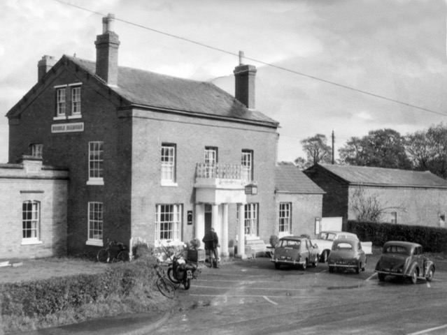
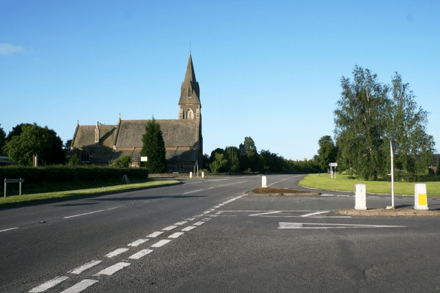
A dangerous crossroads until the 1970s when the A4104 road to Little Malvern was moved 100m to the north. The B4208 has priority over the A road. In the background is the parish church of St James.    © Copyright Bob Embleton and licensed for reuse under this Creative Commons Licence.

The earliest maps of the area do not show roads at all. Instead, they focus on watercourses as markers in the landscape. However, Speed’s 1610 map of Worcestershire shows a bridge at Upton, suggesting an east-west routeway through the region. Furthermore, Welland was part of Bredon manor in medieval times and goods and stock were transported between Welland and Bredon, again suggesting a regularly used route east-west. In the fourteenth century there are records of pigs from Bredon being sent to pasture in the woods at Welland and when logs were transported from Welland to the Severn by people from Bredon in 1395-6, a wassail was provided. Upton’s importance as a port created traffic through Welland – as early as 1289 the Bishop of Hereford had his wine sent from Bristol up the Severn to Upton, after which it was transported by land to his palace in Hereford.

It is possible that the east-west route has existed since prehistoric times. Welland lies close to the ancient frontier of the Malvern Hills, between a crossing of the River Severn (at Upton) and the Dobunni Iron Age hillfort at British Camp. Another Iron Age settlement (possibly a grain management site) has been found recently on the same route, on the far side of the river near Upton. The route extends on to Bredon Hill, yet another hillfort site. Thus the route passing through Welland may have been a significant part of the Dobunni communication and transport network.

At first sight, Welland appears to be in a relatively flat area but a look at a combined LIDAR/aerial image (zoom in towards the red dot and use the slider to view with aerial photography) shows the lumps and bumps of the topography. It therefore seems likely that the routeway, and possibly the village itself, are sited where they are because the brook has cut through a ridge here, providing easier access up to the higher ground and the Hills.

A 1628 survey map of Malvern Chase names the route as Drake Street as it passes through the village (still its name today). Drawings of houses on the 1628 survey map hint at the existence of other roads (or tracks) such as that along the edge of what was then Welland Common (now the B4208), and also Woodside Lane.

There will have been other routeways but these are not recorded on maps before the mid-nineteenth century. The road from Drake Street to Welland Court and the old church (see map) must have been a routeway for centuries. Byefield Lane (see map) is an example of a road that presumably existed in medieval times, passing as it does alongside Westfield, one of the village’s common fields. There are many footpaths over and around the common fields too – evidence that these have been rights of way for a very long time.

Some old routeways have been “lost” over the years. The 1628 survey map shows a route heading south in Little Malvern, at the base of the Malvern Hills and a 1720 plan of Little Malvern also marks this route, naming it as “the road to Gloucester”. This suggests it was a major road, now only discernible as various minor roads and tracks along the base of the steep slope of the hills.

Roadways did not always have a system of maintenance. From the sixteenth century, it was up to each parish to manage their road system and this was a haphazard affair, despite appointment of (unpaid) Surveyors of the Highways to supervise the work. Pot holes, ruts and mud abounded, resulting in frequently used routes becoming very wide as users tried to avoid the terrible conditions along the centre. A Welland example of local maintenance responsibilities comes from historical evidence from the sixteenth century that shows that the maintenance of the road bridge over the brook at Brookend was the responsibility of the one of the copyholders who was allowed to take wood from the Bishop’s land to maintain the bridge. But there are few references in Welland’s parish records to highway maintenance so it seems reasonable to assume that the parish did not make road maintenance a high priority. In 1633, Welland was one of several Worcestershire parishes to be rebuked for the state of its roads. During the latter part of the nineteenth century responsibility for the upkeep of the roads was gradually removed from the parish and placed in the hands of other authorities. However, one major road (what is now the A4104) ceased to be the responsibility of the parishioners much earlier than this. From 1663 onwards, turnpike trusts were empowered to build roads and levy tolls from users – see our separate article on Turnpikes and Tollhouses.

The A4104 remains a major route through Welland for traffic heading east-west between Upton on Severn and Ledbury, though the B4208 heading north-south has become a second significant road in more recent years, providing a route between Worcester and Gloucester (and to the M50). This road crosses what used to be Malvern Chase and, as the road crosses the southern parish boundary, it passes immediately into the largest remaining piece of the Chase, Castlemorton Common.

Other roads were created or enhanced as a result of the Welland Enclosure Act, as a result of which the part of Malvern Chase in Welland parish was enclosed. The Inclosure Map of 1849 marks the road from Danemoor Farm towards The Hook as “New Road”. Such roads are typically very straight, following new large field boundaries.

The crossroads of the A4104 and B4208 has stimulated recent development of the village around this point so that the area around the crossroads is now considered the village centre. The crossroads also demonstrates the continuing development of our road system – the school is now bypassed by the main road.
Summerfield

Summerfield was built on Gloucester Road (B4208) in the early 1850s, after the land was enclosed from Welland Common and the plot sold to Sarah Bullock. It was a generous plot, 2.819 acres as shown on the 1886 ordnance survey map. It was only the second house to be built on that side of the road between the crossroads and the edge of the common.

The original one-up one-down house had a bread oven. There was a smaller single storey building against the boundary line, possibly another dwelling or a business. A well between the buildings still exists.

The Wagstaff family were occupants but not owners in the census returns of 1891 and 1901. When the house was auctioned in 1903 a Miss Wagstaff was tenant. The advertisement names the house as Summerfield, formerly Dutfields. (William Dutfield was one of the early owners.) It was described as a cottage with sitting room, three bedrooms, usual domestic offices and outhouses, etc. The rent was £26 per year.

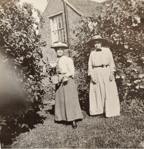
In 1908 the house and 0.75 acre of land were sold to Miss Harriett Thompson, who was already there as a tenant. Harriett described herself as lady gardener in the 1911 census. This photograph of two ladies in the 1900s is believed to show Harriett standing outside Summerfield but we do not know which of the two she is or the identity of the other lady.

By the 1921 census Harriett was recorded as a market gardener. This census also lists Clara Alcock as a boarder, and Robert and Margaret Carless as visitors.

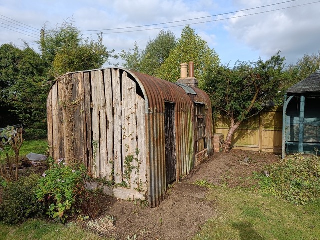
Winifred Postlethwaite was living there at the time of the 1939 National Register. The house was requisitioned by military personnel during the war, with Winifred being relegated to living in a purpose-built nissen-style hut in the garden. This was provided with essentials such as a chimney and cooking stove and an outside solid fuel heated laundry tub. The hut had survived in a dilapidated state, as shown in this photo, when the current occupants moved in a few years ago; it has since been restored, retaining all its original features, to make a pleasant garden-room.

The original plot was gradually sub-divided and is now occupied not only by Summerfield but also Orchard Close, Sunnymede, Red Gables and the village shop.

Photo credits: Sue Haywood

John Archer (d. 1640)

John Archer was a son of Humphrey Archer of Umberslade Hall near Tanworth in Warwickshire. His name appears in the court rolls for Welland from 1607 but he may have settled here earlier. He married Eleanor Frewen of Hanley Castle and they had at least seven sons. He was buried under the chancel of old St James Church, a privilege only granted to the most important people in the parish.

John appears to have lived at Hunts Farm (later known as Woodside) and in his will of 1640 he left this property and the water mill plus various pieces of land, to his wife. The extent of his landholdings is shown by the fact that in 1648 Eleanor was paying more than 25% of the total rent due for the manor of Welland.

Another three generations of John Archers followed in Welland. The hearth tax records of 1663 state that the house of John Archer, grandson of the above, had five hearths, second in number only to Welland Court, making it likely to have been Hunts Farm. In 1672 St James Church was re-built. An engraved stone was put up in the new church to commemorate this event, naming churchwardens John Archer and Ralph Taylor as well as the vicar Anselm Harford and architect John Avenant of Kings Norton. This John Archer died in 1713, pre-deceased by his son John in 1701.

The parish records for Welland are particularly sparse for the 17th century but there are few records under the name of Archer in Welland for any period. There are, however, many more in the surrounding parishes, who may or may not be related to the Welland Archers. A much later John Archer (1791-1877), who ran the Foley Arms Hotel in Malvern for many years, claimed descent from the Welland Archers, but we cannot substantiate this.

Woodside

Woodside. Photo by Phil Blackman

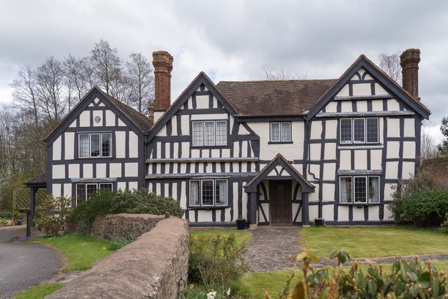
Woodside, now called Willow Grange, is a handsome timber-framed and brick house, one of the oldest in Welland. Its grade II listing describes it as probably 16th and early 17th century with 20th century additions. At the back of the house are the remains of a moat (see aerial image). The house lies off a track leading from the B4208 (see map).

The house is likely to be the one shown in approximately the correct position on the 1628 survey map of Malvern Chase and was probably called Hunts Farm before Woodside. John Archer is known to have owned Hunts Farm as it is mentioned in his will of 1640.

William Boulter owned Woodside from at least 1788 to his death in 1817. He was one of the Boulter family who provided three successive vicars to Welland between 1762 and 1828 but he was not a member of the clergy himself. His widow inherited it and then his son, also William.

Charles Mayfield Turner rented the estate in the 1840s from Thomas Hornyold. It was later farmed by Abraham Watkins, who was to donate the land for St James Church in the 1870s.

As the name suggests, the estate once adjoined and possibly included substantial woodland. A timber auction in 1829 advertised several lots of trees including 161 elms, 35 oak and 74 ash, all from Woodside. Welland Mill also seems to have been part of the estate until at least the mid-19th century.

In 1879 Woodside was bought by James Hartill Purser, whose father had owned coal and iron mines in Cradley Heath. The estate comprised 220 acres at the time. The family were there for about 20 years before moving to Church Villa. Woodside was then farmed by Frederick Hamilton and by 1939 stock farmer William Morris and his wife were living there.

The Birmingham Daily Post advertised Woodside for auction in July 1973, describing it as a ‘fine Elizabethan house’ with three cottages, farm buildings and 175 acres.

Most of the remaining land was later sold to the Ross-on-Wye Steam Engine Society to provide a permanent site for the Welland Steam & Country Rally, held in Welland since 1993.

The Laurels

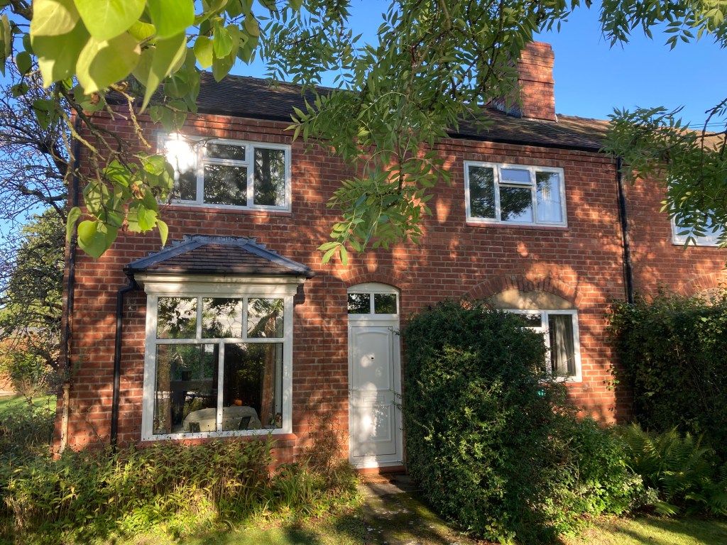
Nos. 1 and 2 The Laurels are a pair of double-fronted semi-detached brick villas on the Gloucester Road, built in the 1890s. This section of the road between the crossroads and the common was still very rural at the time. The 1904 OS map shows that only three properties then fronted the west side of the road: Boundary Cottage, The Laurels (at position 332) and Summerfield, the rest of the land being fields.

Amongst the families who have occupied these houses are the Godwins at no. 2, who were in residence by 1921. Ernest Godwin was originally a wheelwright but worked for many years in Welland as a carpenter, builder and undertaker, building everything from pig huts to air-raid shelters to houses.

No.2, The Laurels

Queen Victoria’s Jubilee

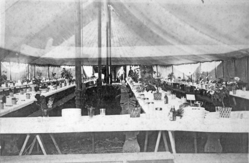
The Worcestershire Chronicle and Worcester Journal of 4 June 1887 published long, detailed accounts of the recent celebrations held at Welland to mark Queen Victoria’s Jubilee, the 50th anniversary of her accession. Following a thanksgiving service at the church in the morning, the villagers moved to ‘a field near the church’* lent by Mr James H Purser of Woodside. A marquee 158 feet long accommodated 400 people, who sat down at 1.30 pm to a lunch of cold beef, veal, potatoes, plum pudding, beer and cider. Flower and fern decorations adorned the tables. Speeches were made and toasts drunk. Vicar of Welland, the Rev John M Donne, praised the ‘kindness, love and womanly devotion of the Queen‘ and claimed that ‘their children’s children would look back to the Victorian half century as the most glorious time in the history of this country.’ Colonel Sir James Johnstone declared that ‘during the last 50 years there has been more progress in morals, in religion and in the general welfare of the country than in any other 50 years in the history of the world’.

Tea was served at 4.00 pm to the 300 children of the parish. Various ‘old English games’ followed and there were merry-go-rounds, dancing on the green and swingboats plus a programme of races for the men and children. The band of the Worcester Regiment and the Upton Brass Band accompanied the day’s proceedings. A fireworks display rounded off the evening.

Funds for the event were raised by subscription and it was organised by the Rev Donne and the two churchwardens, Mr Ludford Docker of the Old Vicarage and Mr James H Purser. The ladies’ committee of Mrs Davis, Mrs Purser, Mrs Dent and Mrs Donne organised the tea and were also responsible for making 250 lbs of puddings and cooking the beef, this being done at Woodside. Mrs Ketteringham, landlady of The Pheasant, also provided refreshments.

Welland was reported to be the first village in Worcestershire to celebrate the Queen’s Jubilee and the Rev Donne explained that this was because the people of Welland ‘were so overflowing with loyalty that they could not wait’. Events in other villages and towns took place around 20 June, the Queen’s actual accession date.

*There is some doubt as to the exact location of this field. It is possible the whole event following the church service took place at Woodside.

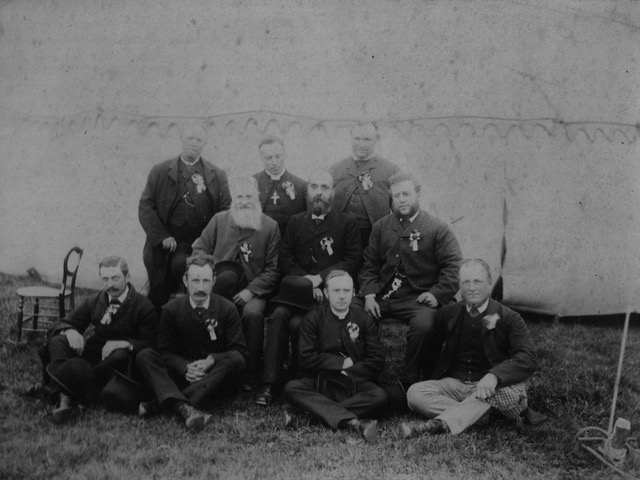
The men’s committee. Front row, 2nd is Ludford Docker, 3rd the Rev John M Donne and 4th James H Purser. Photo provided by Mary Purser
Inside the celebration marquee. Photo provided by Mary Purser

Post Offices

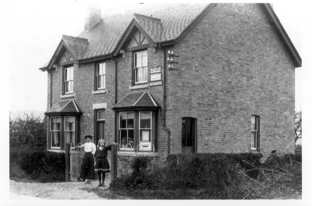
Thomas and Alice Pullen ran the village post office from about 1904 to the mid-1930s from this house on the Gloucester Road (see map). The photo dates from 1909 and the woman and girl are almost certainly Alice Pullen and her daughter, Dorothy. They seem to have run the post office briefly from Vicarage Cottage, on the Marlbank Road, before moving here.

Thomas was originally a coachman but by the time of the 1921 census was described as a ‘painter (out of work)’. Alice seems to have been principally concerned with the post office business, listed as a post office clerk in 1911 and a sub-postmistress in trade directories in the 1920s and early 1930s.

The post office later moved to Myrtle Cottage on Drake Street, where Myrtle Price ran it for about 30 years, but in the meantime the house on Gloucester Road became the village shop and remains so today.

It was common for the early village sub-postmasters to run the post office alongside another occupation and to be assisted in the post office work by their wives. The first sub-postmaster in Welland was Richard George, appointed in 1855. In the 1861 census he is recorded as a shoemaker and his wife Ann was listed as ‘midwife, post office’. They lived at the ‘Post Office, Drake Street’ but we do not know at present which building that was.

Later sub-postmasters were James Grice, who was a grocer, probably in the Brookend area, and Thomas Pear. We do know that James Grice appeared in Billing’s 1855 Worcestershire directory as a farmer and shopkeeper on Drake Street and the property may have been Slade Firs, where he was certainly living by 1860. He was sub-postmaster by the early 1870s and was followed at Slade Firs by sub-postmaster Thomas Pear from 1876-1879. George Jenkins took over in the 1880s, running a combined post office and grocer’s shop from the house now known as The Old Post Office on Drake Street. He was evidently a busy man, as the 1892 Kellys Directory lists him as grocer, assistant overseer, school attendance officer and rate collector. He also acted as enumerator for the Welland census in 1891 and 1901. George Jenkins was succeeded by Thomas Pullen.

Early History

The origin of Welland is uncertain and little documentation exists for its early development. Medieval documents refer to it as Wenlond or Wellond, perhaps meaning that in Anglo-Saxon times the land belonged to someone called Wenna.

Prehistory

Although there is unlikely to have been any significant settlement here in prehistoric times, the village lies close to the ancient frontier of the Malvern Hills and is on the route from a crossing of the River Severn (at Upton) to the Iron Age hillfort at British Camp (now the A4104). Another Iron Age settlement has been found recently on the same route, on the other side of the river. It has been suggested that this settlement forms part of the system used by the local tribe, the Dobunni, to control the region, including the distribution of cereal harvests stored at sites in the Severn valley. The route extends on to Bredon Hill, yet another hillfort site. Thus the route passing through Welland may have been a significant part of the Dobunni Iron Age travel network. (See Worcestershire Archaeology report.)

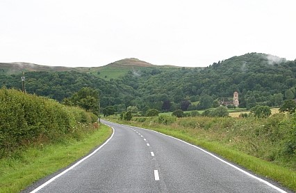
British Camp seen from the A4104 heading up from Welland

An archaeological evaluation by Worcestershire Archaeology (unpublished) was undertaken at Cornfield Meadows in 2020 (see map) and revealed a number of enclosure ditches and associated features at the northern end of the site close to the Marlbank Brook and its tributaries. It was dated by pottery to the later Iron Age and is probably an enclosed prehistoric settlement located within the fertile farmland adjacent to the brook. Evidence of extensive burning was recovered, including both heat affected pottery and Malvernian rock. The Malvern area provided a major regional focus for Iron Age pottery production, with rock from the hills used to temper locally produced pottery. It was therefore tentatively suggested that the site might have an association with pottery production.

Medieval

The first documented reference to Welland states that the village, together with Upton, was given to the Bishop of Worcester by Mercian lords in 889, perhaps as part of their support for the developing Christian church (the document’s authenticity is disputed.) The area was heavily wooded and it is unlikely that many people lived here – as late as the twelfth century the area around Malvern was referred to as wilderness.

Welland is not mentioned in the Domesday Book of 1086, probably because it formed part of the manor of Bredon. Several parishes in the area were subsidiary parts of manors further east in the more agriculturally developed zone of the Severn and Avon valleys. The western parts of the estates provided wood for tools, utensils, fuel and building, as well as woodland resources such as honey and game. Woodland areas were also valuable for the pasturing of swine – it may be that this began as a form of transhumance, the seasonal movement of stock from predominantly agricultural areas for summer pasture. Thus the linking of Welland with Bredon was on a sound economic principle, that of complementary resources.

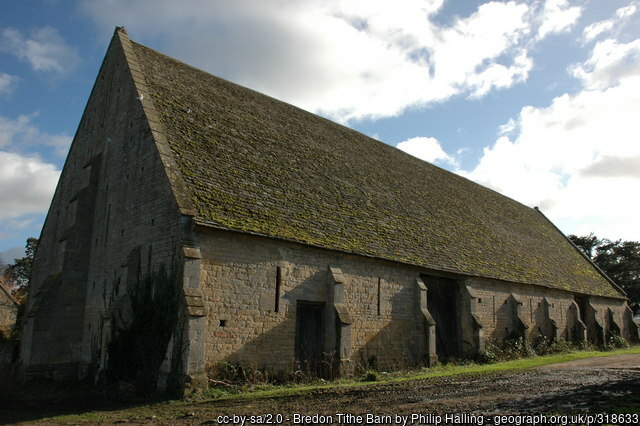
Bredon’s 14th century manorial barn

After the Norman Conquest of 1066, Welland was one of thirteen parishes that were incorporated into William the Conqueror’s Royal Forest, commonly known as Malvern Chase, and subject to forest law. The owner of the land (the Bishop of Worcester) and those living on the land were subject to rigorously enforced rules about the use of the land, which aimed to protect hunting rights. Some clearings had been made before the Conquest but after afforestation, no further clearings were allowed unless permitted by licence of the king.

34 acres in Upper Welland were freed from forest law by Richard I in 1189 and in 1196 the Bishop of Worcester was allowed to extend his clearing by a further 300 acres. Such clearance is called assarting and explains the existence of Assarts Road in Upper Welland. The assart was said to be “neare the Bishoppe’s myll of Wenlonde.” It seems that Upper Welland developed as a distinct community from early times, with another forming around the area near Welland Court.

Taxation assessments suggest that by 1280 approximately 80 people lived in the village, increasing to about 130 by 1327. The population was particularly dense in Upper Welland, perhaps because of the unusual economic approach of letting out assarted land to tenants for money rent. The standard land economy at this time was to let to tenants who paid their rent by manual labour on land (desmesne) retained by the lord of the manor (the Bishop in this case).

In the area around Welland Court, meanwhile, another community was developing along more traditional lines. There is little documentary evidence to support it, but it is likely that this community worked large open fields split into strips and apportioned to individual tenants, with the fields being managed on a crop rotation system. It may be that this community developed earlier than that at Upper Welland – though there is no documentary evidence to support this idea, the traditional agricultural approach and the presence of the Court and church suggest this may be so.

Peasants in the middle ages were mostly tenant farmers but there were also small-scale industries such as potting and tile-making (evidence of clay pits abounds).

The manor had probably been separated from Bredon before 1535 because, in the valuation of the bishop’s lands taken at that time, it is entered apart from Bredon and had a separate bailiff.

Cecilia Campbell

Article written by Rose Arno (nee Campbell), June 2023

Cecilia Dudley Campbell, my mother, moved to Welland in 1935 after marrying my father in April 1934. She grew up in Upton-on-Severn, the adopted daughter of Blanche Fowler, a Methodist deaconess and owner of a temperance café in Upton. Blanche had ambitions for Cecilia (she was very keen on education) and after Tewkesbury High School and a few years working as a trainee teacher, she  obtained a place at Dudley Training College. She worked in Birmingham and Malvern before being appointed to the infants’ head post at Welland School.

My brother Patrick was born in July 1935 and they moved into the school house at Welland. Mr Band, the headteacher, preferred his bungalow in Upper Welland. Apparently the school house, though uncomfortable and draughty, had some modern conveniences like a flush lavatory (albeit off the kitchen) and some kind of bathroom – all quite unusual then.

Welland School House before it was incorporated into the main school building. Courtesy Alison Ellis.

I think after the war, when the village expanded with council housing and baby boomers, it was decided (by my mother) to move the infants’ class into the parish hall. She seems to have had a great deal of autonomy in this respect but it was a good decision. The downside was that they also served school dinners in the hall, but the stage was ideal for her annual nativity play, and  it was large and roomy for the numerous  pupils,  all different ages and abilities. By 1946 the school house was needed for the new head, Alex Clarke, so my parents moved to Camelot, Brookend, where I was born in August 1946.

She loved her job which she saw as a genuine vocation and I believe she was an excellent teacher. She once boasted that she had ‘never had a child who couldn’t read’.

She was very active in village affairs and a member of the WI, Mothers’ Union and Parochial Church Council.  My father was the vicar’s warden. However, she always wanted a headship and this dream was realised when she was appointed to be head at Corse Lawn school in the early 1960s. She retired in 1974.

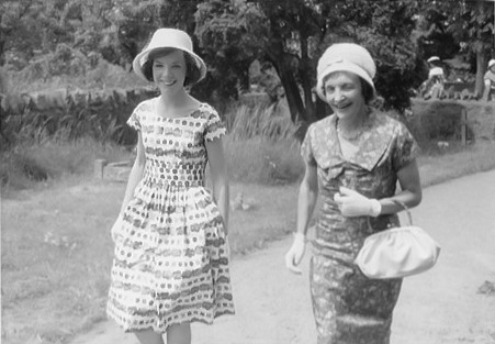
Cecilia Campbell (right) and her daughter Rose attending a wedding in 1960. Courtesy Rose Arno.

The Pheasant

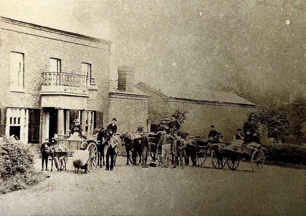
The Pheasant in the second half of the nineteenth century, the earliest photograph we have

The Pheasant pub stands at the crossroads of Drake Street and the Gloucester Road (see map). This handsome building was completed by early 1843, when the owner was James Archer and the tenant Samuel Ingles. It replaced an earlier Pheasant Inn about 100m further along the road towards Upton. The timing of the rebuild suggests that the owner was keen to take advantage of the expected increase in traffic caused by the creation of improved roads and crossroads as a result of the anticipated enclosure of the common (the Welland Enclosure Act was passed in 1847).

The earliest record of The Pheasant we have found to date is an advertisement for sale by auction in 1774, when it is stated as consisting of the Inn and two orchards, occupier Ann Grubham and proprietor Richard Lutwich. Its position is emphasised, being adjacent to the Chase and on the Upton to Ledbury turnpike road.  Later advertised for auction in 1834, the Pheasant then consisted of the inn, stable, cider-house, and about two acres of pasture and orchard. The pub passed through various hands in the 18th and 19th centuries but seems never to have belonged to any one family for long.

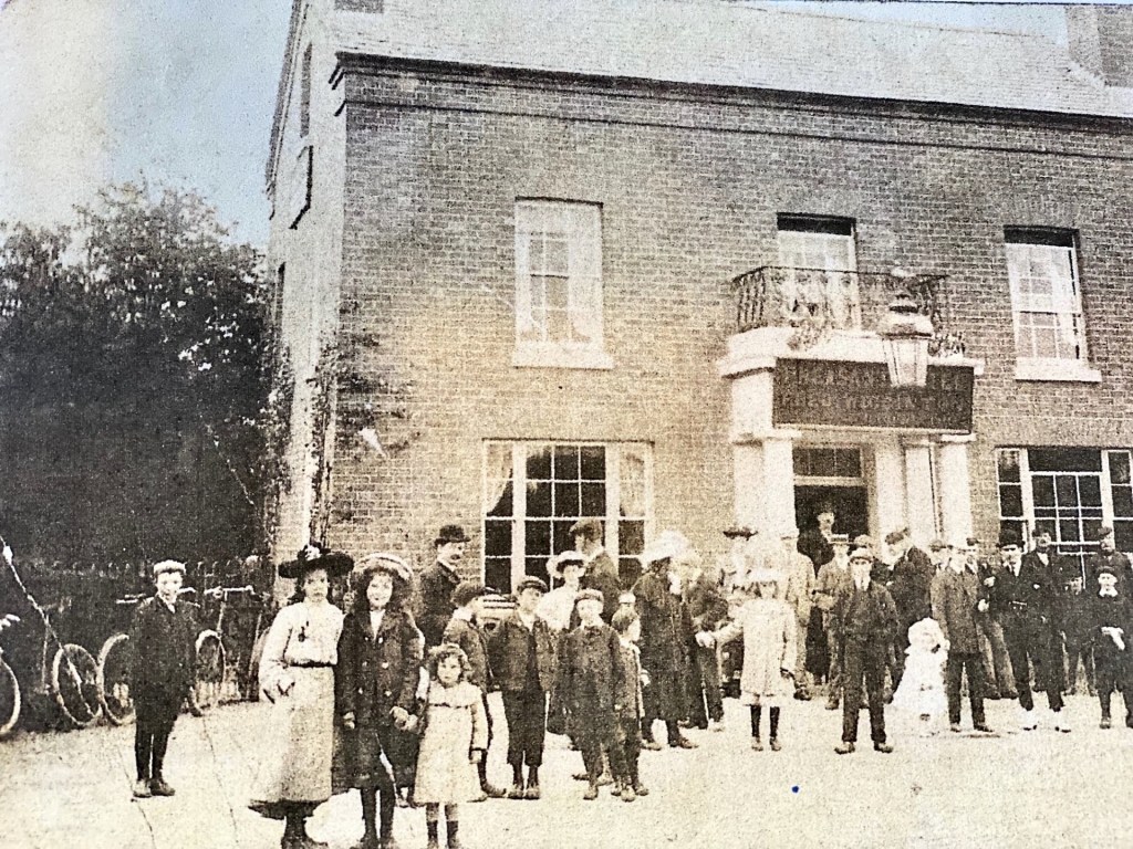
The Pheasant (date between 1901-1906) when Ralph John Hunter was the owner and Fred Wiggington was the licensee

The Pheasant circa 1911 when John (Jack) Walker Thompson was the licensee (that’s probably him wearing the apron)

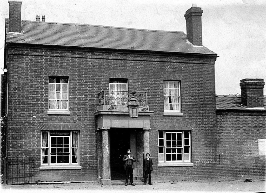
The Pheasant sometime in the 1920s when Henry Jefferson Bryon was the landlord (he is on the left).

Francis Elms became tenant in 1929, when the value of the fixtures, fittings and stock in trade was valued at £192 18s. He and his wife Violet ran the pub until they retired in 1955. It was then taken over by their son, Southwell Elms, and his wife Rhoda, who continued until their retirement in 1982. Southwell was responsible for having the function room built, providing a dance floor and room for a band.

The Pheasant in the early 1960s. Courtesy of the Elms family.

The pub closed in 2010 after a succession of tenants were unable to make it pay all year round. The spacious car park behind the pub was sold off for housing, now St James Close. Various plans for a combination of pub or restaurant and apartments fell through but renovation work is currently under way (2025). The planning application states that the original Pheasant Inn will be converted into three apartments, with an extension providing a further two dwellings. A second extension will provide space for a combined cafe, bar and restaurant.